Storm surge events on the North Sea

12/26/838
First documented storm surge in the North Sea; Approximately 2,500 deaths in what is now the Netherlands.

2/17/1164
First Julian flood: 20,000 dead; First collapse of the Jade Bay, major damage in the Elbe area.

1/16/1219
First Marcellus flood: 36,000 dead: major floods also in the Elbe area; first conveyed eyewitness report.

12/28/1248
Allerkindslein flood: High loss of human life. The historic Elbe island of Gorieswerder is divided into several parts.

12/14/1287
Lucia Flood: Beginning of the formation of the Dollart, 50,000 dead.

11/23/1334
Clemens Flood: Expansion of the Jade Bay.

1/16/1362
Second Marcellus Flood, Grote Manndranke: 100,000 dead: first collapse of the Dollart, expansion of Leybucht, Hariebucht, Jade Bay and Eider Estuary, sinking of large parts of North Frisia.

10/09/1374
First Dionyslus flood: Largest extent of the Leybucht up to the city of Norden, sinking of the village of Westeel near Norden.

9/10/1377
Second Dionysiusflut: Dikes near Lütetsburg and Bargebur
torn, the waves hit the walls of the Dominican monastery in Nord.

11/21/1412
Cacilien flood: An entire village at the mouth of the Este was destroyed, and the Elbe island of Hahnöfersand was separated from the mainland.

11/1/1436
Allerhelligen flood: Flooding on the entire North Sea coast, especially in Eiderstedt and Nordstrand.

1/6/1470
Epiphany Flood: Flooding in Eiderstedt, no permanent land losses.

09/26/1509
Cosmas and Damian flood: Breakthrough of the Ems
near Emden, largest expansion of the Dollart, last expansion of the Jade Bay to the northwest.

01/16/1511
Antonius flood, ice flood: breakthrough between Jade and Weser.

10/31 and 11/1/1532
Third All Saints Flood: Several thousand dead in North Frisia, first peak value recorded in the church of Klibüll; Sinking of Osterbur and Ostbense in East Frisia.

11/01/1570
Fourth All Saints Flood: Flooding of the marshes from Flanders to Eiderstedt: large dike breaches in the Altes Land as well as in the Vier- und Marschenlanden; Sinking of the villages of Oldendorf and Westbense near Esens: 9,000 to 10,000 dead between Ems and Weser. High tide mark at the Suurhusen church at NN +4.40 m.

2/26/1625
Carnival flood: An ice flood, dike breaches and major damage in East Frisia and Oldenburg, in the Altes Land and Hamburg, many dikes breaches on Jade and Weser.

10/11/1634
Second Grote Manndranke: Strand Island sinks; What remains are the islands of Nordstrand and Pellworm; at least 8,000 dead.

2/22/1651
Petri flood: “Dane chains” broken on Juist and Langeoog, Dornumersiel was destroyed, there were dike breaches on the mainland.

11/12/1686
Martin’s Flood: Severe damage to dikes from the Netherlands to the Elbe.

12/24 to 12/25/1717
Christmas flood: 11,150 dead from Holland to the Danish coast: the largest storm surge known to date with flooding and devastation of enormous proportions.

12/31/1720 to 01/01/1721
New Year’s flood: higher than Christmas flood; Destruction of the dikes that were poorly repaired after 1717; Sinking of the villages Bettewehr II and Itzendorf

2/3 to 2/4/1825
February flood: 800 dead; There were many dike breaches along the coast and severe loss of dunes on the islands. Highest storm surge on the Elbe until 1962.

1/1 to 1/2/1855
January flood: Heavy destruction on the East Frisian Islands, storm surge mark on Norderney at NN +4.26 m.

3/13/1906
March flood: highest storm surge recorded to date on the East Frisian coast.

1/31 to 2/1/1953
Dutch flood: worst natural disaster of the 20th century in the North Sea area. In the Netherlands approx. 1,800 dead, England and Belgium more than 2,000 dead; Total damage more than €500 million: no major damage to the German coast, but an impetus to check the dikes.

2/16 to 2/17/1962
February storm surge, Second Julian flood: 340 dead, 19 of them in Lower Saxony, approx. 28,000 apartments or houses damaged and 1,300 completely destroyed; highest storm surge to date East of the Jade with 61 dike breaches in Lower Saxony; The Elbe area and its tributaries were particularly affected.

1/3/1976
January flood: highest storm surge to date on almost all pegs on the German North Sea coast: numerous dike breaches in Kehdingen and the Haseldorfer Marsch.

11/24/1981
November flood: Highest peak water level in North Frisia with NN +4.72 m at the Dagebüll gauge.

1/28/1994
January flood: Highest peak water levels on the Ems with NN +4.75 m at the Weener gauge and on the Wese with NN +5.33 m at the Vegesack gauge.

12/3/1999
Anatol: short-term increase with very high water levels in the entire North Sea region; The storm subsided before the astronomical flood occurred in Cuxhaven, otherwise the values ​​of 1976 had been exceeded in the Elbe area.

11/01/2006
Fifth All Saints Flood: Very severe storm surge with water levels exceeding the 1994 levels in the Ems area, dike collapses on the East Frisian islands of Juist, Langeoog and Wangerooge…

This list was assembled by Christian von Wissel of Bremer Zentrum für Baukultur. It was part of the exhibition “Deichstadt #1” in spring 2024.

Sturmflutereignisse an der Nordsee

26.12.838
Erste dokumentierte Sturmflut an der Nordsee; ca. 2500 Tote im Gebiet der heutigen Niederlande.

17.02.1164
Erste Julianenflut: 20.000 Tote; erster Einbruch der Jade, große Schäden im Elbegebiet.

16.01.1219
Erste Marcellusflut: 36.000 Tote: große Überflutungen auch im Elbegebiet; erster überieferter Augenzeugenbericht.

28.12.1248
Allerkindsleinflut: Hohe Verluste an Menschenleben Zertrennung der historischen Elbinsel Gorieswerder in mehrere Teile.

14.12.1287
Luciaflut: Beginn der Bildung des Dollarts, 50.000 Tote.

23.11.1334
Clemensflut: Erweiterung des Jadebusens.

16.01.1362
Zweite Marcellus-Flut, Große Manndränke: 100.000 Tote: erster Einbruch des Dollart, Erweiterung von Leybucht, Hariebucht, Jadebusen und Eidermündung, Untergang von großen Teilen Nordfrieslands.

09.10.1374
Erste Dionyslusflut: Größte Ausdehnung der Leybucht bis zur Stadt Norden, Untergang des Dorfes Westeel bei Norden.

09.10.1377
Zweite Dionysiustlut: Deiche bei Lütetsburg und Barge-
bur zerrissen, die Wellen schlugen an die Mauern des Dominikanerklosters zu Norden.

21.11.1412
Cacilienflut: An der Estemündung wurde ein ganzes Dorf vernichtet, die Elbinsel Hahnöfersand wurde vom Festland abgetrennt.

01.11.1436
Allerhelligenflut: Übertflutungen an der gesamten Nordseoküste, insbesondere in Eiderstedt und Nordstrand.

06.01.1470
Dreikönigsflut: Überflutungen in Eiderstedt, keine bleibenden Landverluste.

26.09.1509
Cosmas- und Damianflut: Durchbruch der Ems
bei Emden, größte Ausdehnung des Dollarts, letzte Erweiterung des Jadebusens nach Nordwesten.

16.01.1511
Antoniusflut, Eisflut: Durchbruch zwischen Jade und Weser.

31.10/01.11.1532
Dritte Allerheiligenflut: Mehrere tausend Tote in Nordfriesland, erste Höhenmarke des Scheitelwertes überliefert in der Kirche von Klibüll; Untergang von Osterbur und Ostbense in Ostfriesland.

01.11.1570
Vierte Allerheiligenflut: Überflutung der Marschen von Flandern bis Eiderstedt: große Deichbrüche im Alten Land sowie in den Vier- und Marschenlanden; Untergang der Dörfer Oldendorf und Westbense bei Esens: 9.000 bis 10.000 Tote zwischen Ems und Weser. Flutmarke an der Kirche Suurhusen bei NN +4,40 m.

26.02.1625
Fastnachtsflut: Eine Eisflut, Deichbrüche
und große Schäden in Ostfriesland und Oldenburg, im Alten Land und Hamburg, viele Ausdeichungen an Jade und Weser.

11.10.1634
Zweite Manndränke: Insel Strand geht unter; Reste sind die Inseln Nordstrand und Pellworm; mind. 8.000 Tote.

22.02.1651
Petriflut: Auf Juist und Langeoog wurden Dänenketten durchbrochen, Dornumersiel wurde zorstört, es gab Deichbrüche am Festland.

12.11.1686
Martinsflut: Schwere Deichschäden von den Niederlanden bis zur Elbe.

24./25.12.1717
11.150 Tote von Holland bis zur dänischen Küste: größte bis dahin bekannte Sturmflut mit Überflutungen und Verwüstungen ungeheuren Ausmaßes.

31.12.1720/01.01.1721
Neujahrsflut: höher als Weihnachtsflut; Zerstörung der nach 1717 notdürftig reparierten Deiche; Untergang der Dörfer Bettewehr II und Itzendorf

03./04.02.1825
Februarflut: 800 Tote; entlang der Küste kam es zu vielen Deichbrüchen und schweren Dünenverlusten auf den Inseln. Höchste Sturmflut an der Elbe bis 1962.

01./02.01.1855
Januarflut: Schwere Zerstörungen auf den Ostfriesischen Inseln, Sturmflutmarke auf Norderney bei NN +4,26 m.

13.03.1906
Märzflut: höchste bis dahin festgestellte Sturmflut an der ostfriesischen Küste.

31.01./01.02.1953
Hollandflut: schwerste Naturkatastrophe des 20. Jahrhunderts im Bereich der Nordsee. In den Niedertan den (ca. 1800 Tote), England und Belgien mehr als 2000 Tote; Gesamtschaden mehr als 500 Mio. €: keine größeren Schäden an der deutschen Küste, jedoch Anstoß, die Deiche zu überprüfen.

16./17.02.1962
Februarsturmflut 62, 2. Julianenflut: 340 Tote, davon 19 in Niedersachsen, ca. 28.000 Wohnungen bzw. Häuser beschädigt und . 1.300 vollg zerstört; höchste bisherige Sturmflut Ostlich der Jade mit 61 Deichbrüchen in Niedersachsen; betroffen war vor allem das Elbegebiet mit seinen Nebenflüssen.

03.01.1976
Januarflut: bis heute höchste Sturmflut an nahezu allen Pegein der deutschen Nordseeküste: zahlreiche Deichbrüche in Kehdingen und der Haseldorfer Marsch.

24.11.1981
Novemberflut: Höchste Scheitelwasserstände in Nordfriesland mit NN +4,72 m am Pegel
Dagebüll.

28.01.1994
Januarflut: Höchste Scheitelwasserstände an Ems mit NN +4,75 m am Pegel Weener sowie an der Wese mit NN
+5,33 m am Pegel Vegesack.

03.12.1999
Anatol: kurzfristiger Anstieg mit sehr hohen Wasserständen im gesamten Nordseegebiot; Abflauen des Sturms vor Eintritt des astronomischen Hochwassers in Cuxhaven, andornfalls waren im Elbegebiet die Werte von 1976
überschritten worden.

01.11.2006
Fünfte Allerheiligenflut: Sehr schwere Sturmflut mit Überschreiten der Pegelwerte von 1994 im Bereich der
Ems, Deichabbrüche auf den ostfriesischen Inseln Juist, Langeoog und Wangerooge …

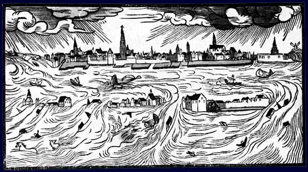
Breach of St. Anthony Dike in 1651

Jan Asselijn (1610–1652): “Breach of St. Anthonis-Dike near Amsterdam”, 1651.

“During the night of 4-5 March 1651 the Saint Anthony’s Dike was breached near Amsterdam. Jan Asselijn portrayed the fiercely flowing water with a strong sense of drama. The billowing cloak of the man at the left shows that the storm is not yet over, however the squalls are already moving on at the right. The vivid red contrasts sharply with the bright blue of the parting clouds.”

(from the website of Rijksmuseum, Amsterdam, NL)

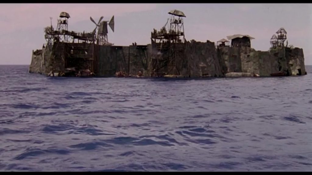
Atoll Settlement from Waterworld (1995)

Image of the swimming settlement in the movie “Waterworld” from 1995. The settlement is called “Atoll” in the movie but in fact it is a human made swimming construction. There is no natural land left known to the population of waterworld.

This sequence from the movie clearly shows the allusion to the Dutch cultural heritage with a windmill and a manually operated large weir mechanism featuring prominently.

Are floating cities a remedy for over-crowded coastal cities, land subsidence and rising sea level?


As this documentary from German TV from 2022 clearly shows, designing floating cities is one thing, wanting to live there is quite another. I guess instinctively we all prefer “stability over floating flexibility”, as director Kristin Siebert says, land over sea, grounded houses over floating houses. As desirable living by the sea might be, living on it, is a different matter.


The film does a fine job connecting and juxtaposing places and communities from the global south and global north, sharing similar fate and trying out similar solutions.


If floating cities are a real future option for communities challenged by climate change like Malé, the capital of the Maledives, we need to look at the socio-cultural and emotional aspects of what makes people feel at home. And that might be essentially the same in the Pacific as in Germany or Holland. Breaking with a culture of habitation of several thousand years is no easy task!

(thanks to Janina Kriszeo for the lead!)

Click on image for video link!

Interview with Sumet Jumsai

The famous Thai architect and artist Sumet Jumsai speaks about solutions for building houses with and not against nature. Here is an excerpt:

Our built environment evolved with nature, not against it. Our national trait is marked by resilience, inventiveness, flexibility and ad hoc programmes to problem-solving. In the central plain, it meant living in amphibious homes or houses on stilts. This is a cultural heritage that has been ignored at a cost.

Please read the full article here.

The case for culture

In a very nice, comprehensive and extensive article, Dutch author Thijs Weststeijn, describes the role of culture in forming a climate conscience. The article not only describes the threats to cultural heritage the world over, particularly flooding, and the efforts to save it, but he also makes a case for using cultural heritage to create awareness and ultimately climate action. Here are two short quotes:

“Perhaps an awareness that the building blocks of one’s own civilisation are under threat might mobilise new groups, for whom the disappearing of coral reefs, say, remains too abstract or remote. Behavioural scientists point out that, when confronted with overwhelming amounts of scientific data, such as that continuously produced by climatologists, people actually become less likely to take action (see Kari Norgaard’s book Living in Denial: Climate Change, Emotions, and Everyday Life, 2011). Instead, people have to be affected on a deep emotional, psychological and spiritual level, which suggests that the layered sensations we experience in encounters with heritage – historical connection, aesthetic appreciation, and solastalgia – might motivate people in new ways.”

“A focus on cultural heritage also offers new perspectives on human agency in the face of the climate crisis. This heritage has, after all, been made by humans and so by human hands we should be able to save it. Besides, historic heritage, while transcending the lifespan of one or more human generations, is less intractable to us than the ‘deep time’ associated with the evolution and extinction of coral reefs and other endangered creatures.”

Weststeijn also sketches future scenarios for cities and cultural sites in the following excerpt:

“One can imagine the partially flooded centres of VeniceHoi An or Miami becoming particularly attractive tourist destinations for the duration of their disappearing (in a state of ‘dark euphoria’ described by the futurist Bruce Sterling in 2009), before turning into a diver’s paradise. And perhaps from the perspective of ‘deep time’ the man-made polder landscape was never a feasible project to begin with, and Dutch hydrologists might eventually, with a sigh of relief, surrender their lands back to the sea. Such visions are not necessarily long-term scenarios since, now, even the possibility of handing our heritage to the next generation appears impossible.”

Divide the Seas!


To counter the global sea level rise, several initiatives have formed to block seas off from the global water flow. The idea behind it: If you control the global water flow, you could control the sea level locally without having to tackle the problem globally. Of course, from a political point of view, this is a case of eco-protectionism taken to the next level. It would create an unprecedented case of separatism, a whole area shutting itself off from global interdependency that is essential to what human culture is – an interdependent global network.

About these plans, one scientist from the Royal Netherlands Institute for Sea Research said: “See this as a warning. What we’re saying is: Here’s a plan, a plan we don’t want. But if we end up needing it, then it’s technically and financially feasible.”

See the article from the New York Times from 2020.


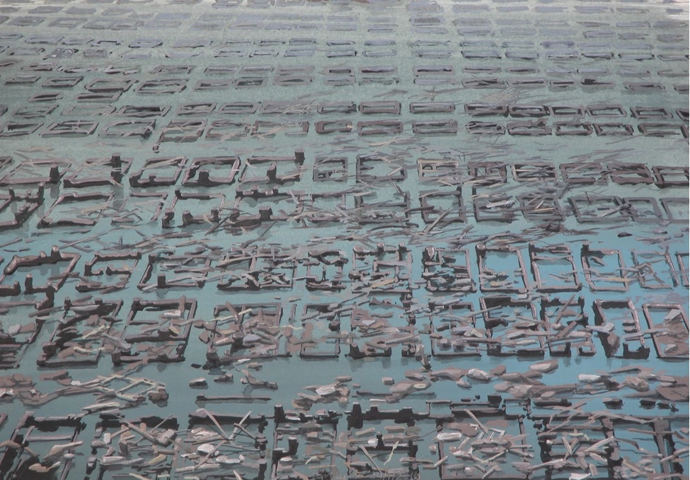
Olphaert den Otter: Beauty without well-being

One of many images from the “World Stress Painting” series Dutch visual artist Olphaer den Otter began in 2019. He calls it: “A never-ending series that lends visual interpretation to the four elements, made by human intervention into catastrophes. A catalogue of beauty without well-being.”

Netherlands; 21. Century; Christian; Painting

The 1953 flood in the North Sea

The events on January 31. 1953 constitutes one of the moste severe floodings in the 20. Century in Europe. More than 1.800 lives were lost in the Netherlands, more than 300 in England and Schottland and 28 died in Belgium. As a direct result of the catastrophic events England began the development of the Thames Barrier and the Netherlands of the Delta Works. The flood has become the source of many musical compositions, books and movies.

UK, Netherlands, Belgium; 20. Century; Flood;