Designing cities below sea level: Paraty, Brazil

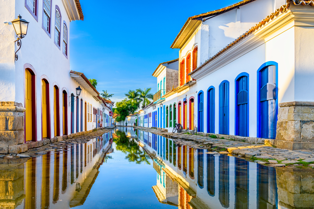
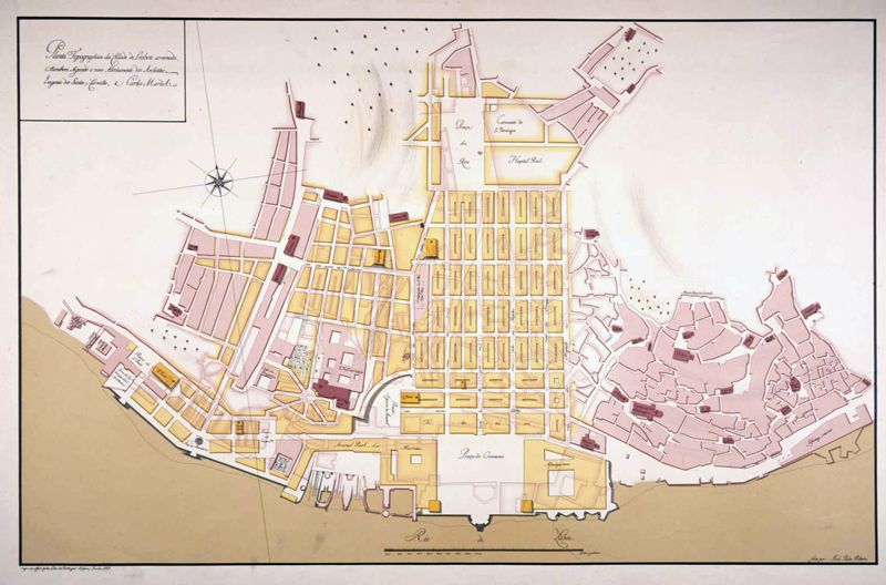
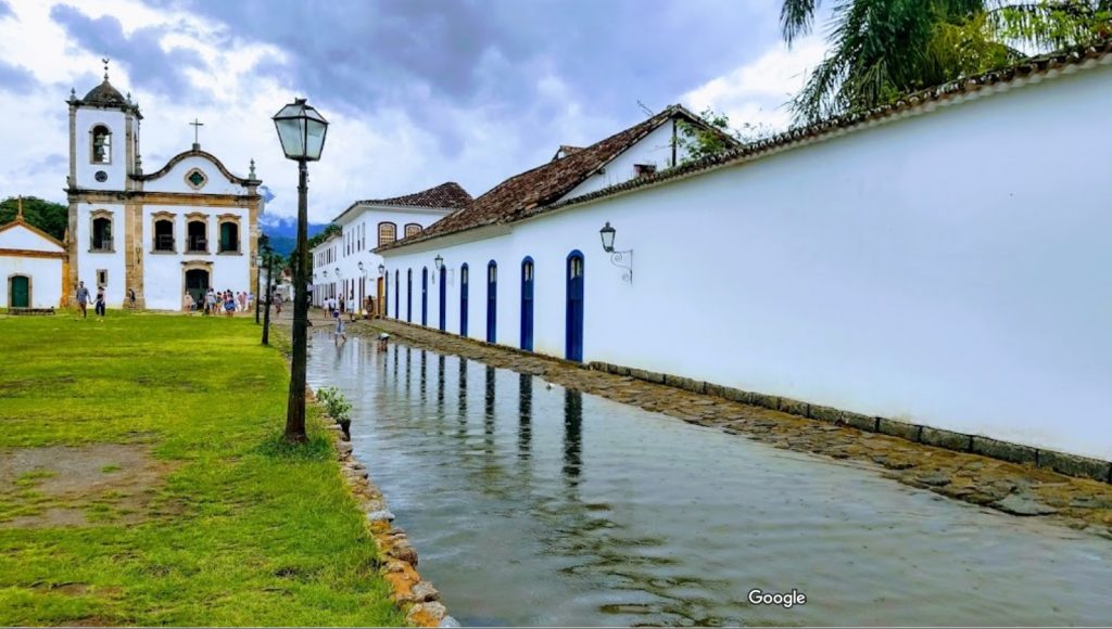
Paraty is a small town and tourist location on Brazil’s Costa Verde, between Rio de Janeiro and São Paulo. Rising as high as 1,300 meters behind the town are tropical forests and mountains. The village was founded in 1597 and established formally as a town by Portuguese colonists in 1667. The region was populated by the Guaianás Indians. Paraty’s historic center has cobbled streets and buildings dating to its time as a port, during the Brazilian Gold Rush around 1700. Since it is located below-sea-level, the streets flood every full-moon at high tide. Instead of keeping the sea water out, the city planners built a sea wall with special openings to let the water flow in and clean the cobble stone streets.

The following excerpt is from an article by Jose Barbedo et al. Full text can be found here.

“The leading Brazilian urban planner Lucio Costa has described Paraty as the city where the ways of the sea and the paths of the earth meet and interlock. This short description synthesizes the unique landscape that surrounds one of the most valuable colonial settlements in South America.

When the first Portuguese settled in this site in the 16th century, the area was composed of wetlands, which were since progressively drained for the construction of the colonial town. The remnants of the floodplain which were not urbanized have been converted for agricultural use, serving as a buffer zone between the city and the mountains. The two river systems flowing into the urban area (Mateus Nunes and Perequê Açu) have steep gradients, bringing rapid discharges of large volumes of storm water onto the floodplain.

The original settlement was planned to cope with regular high tides and common flooding events; the streets were deliberately designed in a “V” shape, sloping down from the curbs towards the center, in order to keep the houses dry while the streets turned into canals. Today, this fragile balance between the city and its natural environment is threatened by unplanned urban expansion, which in turn may also be aggravated by more frequent extreme rainfall events as registered in recent times.”

Torres de Ofir

In the north of Portugal, sea lvel rise causes masssive land loss along the Atlantic coast. The building that has become the most emblematic for the situation along Portugal’s coast are the Torres de Ofir, three towers set between the Cavado river and the ocean front in Esposende, about an hour north of Porto. The Portuguese hydrobiologist and researcher at the Abel Salazar Institute Adriano Bordalo e Sá made the following statement which has become much quoted by the press: ” “Se vivêssemos num país a sério, as torres de Ofir há muito teriam sido demolidas / If we were a serious country, the towers would have been demolished long ago.”

Depending on how the photo is taken, the three towers appear more or less vulnerable to the ocean. Some photo journalists have even opted for a tilted perspective, making the scene appear a bit more dramatic. Here is a selection of recent and historic photos. Clearly the Torres de Ofir are an infamous and much publicized example of the kind of problematic coastal architecture in times of rising sea level.

Blake and Mortimer: The Atlantis Mystery

In the Belgian classic comic series Blake and Mortimer there appeared in 1955 an adventure set in the mythical city Atlantis. It’s the seventh story in the series which started in 1950.

What I find noteworthy is that the city Atlantis here undergoes several metamorphosis: It was once a city (and state) on land. It then got submerged due to seismic events. The citizens however survived and formed a new community in a subterranean system of caves. In the story this “new” Atlantis gets flooded and destroyed once again and the citizens evacuate once more, this time into space.

Since the plot is quite complicated, I mostly quote here from the respective wikipedia entry.

Professor Philip Mortimer takes his vacation to São Miguel, an island of the Azores. In a cave in the extinct volcanoe Sete Cidades he finds a radioactive rock and cannot help making a rapprochement with the orichalcum mentioned by Plato, the mysterious metal of Atlantis.

The comic then tells the following version of the myth:

12,000 years ago, Atlantis ruled the world from an island in the middle of the Atlantic (an island of the Azores) . But the collision between Earth and a huge celestial body caused the submergence of the continental coasts and island. The few survivors of the Atlantean civilization then decided to build a new and secret Atlantis in the bowels of the Earth. The Atlanteans are watching the surface of the Earth thanks to what earthlings call flying saucers.

Blake and Mortimer climb down into a labyrinth of caves and eventually arrive in Poseidopolis, the capital of subterranean Atlantis. Here they get caught in a political uprising to overthrow the royal reign of the state. The uprising results in disaster: Atlantis is flooded a second time, when the flood gates that hold back the ocean are accidentlay opened. The monarchy then orders the evacuation that had been planned for a long time: the departure of the Atlanteans to another planet with an armada of spaceships. While the Atlanteans prepare to join other skies, the other ethnos of this subterranean world, the so called barbarians, are facing extinction in the rising waters. Blake and Mortimer are released and evacuated by a submarine. Back on land, on the shores of the caldera of Sete Cidades, they attend the majestic departure of Atlantean ships into the sky.

The connection between the ocean and outerspace was not an uncommon one in the 1950s as Helen M. Rozwadowski explains in her essay on submarine utopias in the 20. Century. Both – the deep sea and outerspace – held promises of alternate existences for an otherwise doomed human civilization. This also becomes evident in the oeuvre of one of sci-fi’s most important authors, Arthur C. Clarke, who wrote three volumes of non fiction books about the Great Barrier Reef. See my post on Rozwadowski’s essay here.

Original version of the comic book in french language here.

Calcadas Portuguesa

All along the Portuguese coast city squares are adorned with these types of pavements that resemble ocean waves. The Calcadas Portuguesa depict different motivs but the waves are a recurrent feature.

Lisbon after the destruction

After the famous earthquake of 1755 that destroyed much of the city and could be felt all across the Mediterranean and much of continental Europe, the people of Lisbon had to rebuild the city. Portugal’s chief minister Sebastia Jose de Carvalho e Mello (1699 – 1782) was particularly influential in modernizing the old city. He conducted a survey among local priests to find out as much as possible about how people experienced the disaster. He also changed the layout of the city significantly.

This map shows Lisbon before the disaster:

This is a plan for the new Lisbon after the earthquake by architects Eugénio dos Santos and Carlos Mardel:

The Lisbon Disaster

Contemporary etching of the Lisbon harbour during the 1755 earthquake and tsunami. Artist unknown.

Pool at Leça da Palmeira Beach, Portugal

Portugal; 20. Century; Architecture