It’s a rather popular architectural motif, particularly of course in coastal and riverside cities. I wonder if there ever has been a historical study of the wave in architecture. Here are a few random examples from Europe:
Dessauerstraße, Hemshof Ludwigshafen, Germany. I couldn’t find out about the architect nor he date of these buildings.
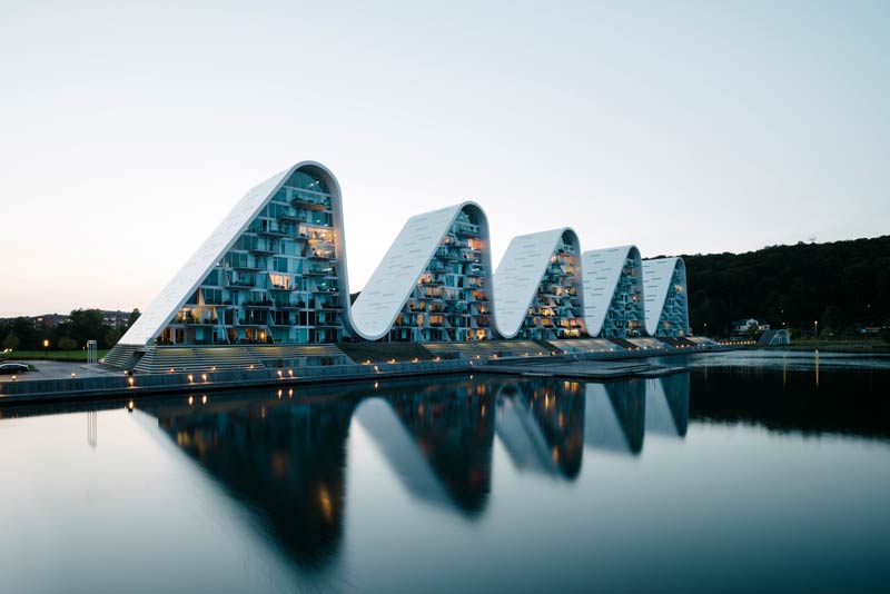
Built over the course of more than a decade and finished in 2018: The Wave in Vejle, Denemark, designed by Henning Larsen.
Elbphilarmonie in Hamburg, Germany. Opened in 2016, by architectural firm Herzog & de Meuron.
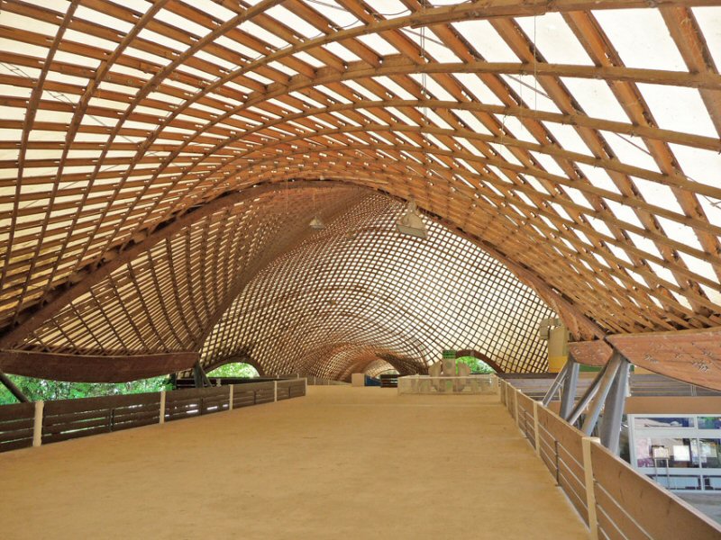
Inside of Multihalle, in Mannheim, Germany, built by Frei Otto in 1975.
There are only a limited number of options to deal with SLR and land subsidence. One of the more obvious ones is raising buildings. There is of course limitations as to how many buildings you can possibly raise to save the habitats from inundation. Raising a whole city? Not likely.
Yet in the middle of the 19. Century the city of Chicago on the shore of Lake Michigan tried just that. The story is so extraordinary that I first assumed it to be an urban folklore from a place that has no shortage of urban legends. By the 1850s, the sanitary and health situation in Chicago had become unacceptable due to large pools of standing and infested water building in the city. Central Chicago is almost at sea level of Lake Michigan, making drainage difficult. In order to install a new sewerage system, the street level of central Chicago as well as most of the buildings had to be elevated between 1 and 2 meters.
The feat was achieved in a piecemeal fashion and over the cause of several years. Many large buildings like the Tremont House hotel (6 stories high and over 1 acre (4,000 m2) of ground space) or the Robbins Building were elevated in one piece by use of jackscrews:
“Business as usual was maintained as this large hotel ascended, and some of the guests staying there at the time—among whose number were several VIPs and a US Senator—were oblivious to the process as five hundred men worked under covered trenches operating their five thousand jackscrews. One patron was puzzled to note that the front steps leading from the street into the hotel were becoming steeper every day and that when he checked out, the windows were several feet above his head, whereas before they had been at eye level. This hotel building, which until just the previous year had been the tallest building in Chicago, was raised 6 feet (1.8 m) without incident.” (from wikipedia)
The Franklin Building was elevated in 1860 not with jackscrews but with hydraulic power. In the local newspapers on April 30th, 1860, citizens were invited to witness the event with the following note on the front page:
“The public are respectfully invited to be present between the hours of 1 and 3 o’clock P. M. on Monday, to witness the process of raising buildings by Hydraulic Pressure, at the four story brick buildings known as the Franklin House, now being raised to grade, and at that hour the machinery will be in operation.”
The images and articles from this period of the city’s history have become emblematic of the spirit of Chicagoans and their entrepreneurial bravery and wit. The Chicago Tribune in 1865 called it a “truly Herculean task”. In a sense, Chicago was really pulling herself up by her boot strings. The story serves as a striking example of how adaptation measures constitute to urban history and identity.
Thanks to Jeff Goodell’s video lecture for the lead.
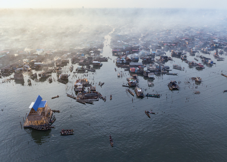
Nigerian architect Kunlé Adeyemi designed this floating building seen in the lower left corner of this photo. “Half-building, half-boat, the floating structure provides teaching facilities for the slum district of Makoko, a former fishing village in Lagos where over 100,000 people live in houses on stilts. Built by a team of local residents, the structure was put together using wooden offcuts from a nearby sawmill and locally grown bamboo.” (source) The Building was designed and built over the course of a year around 2013 and the design was awarded at 2016’s Venice Biennale. See another extensive article here.
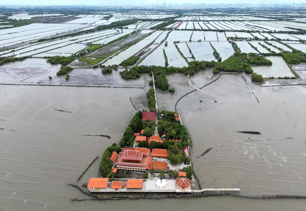
This aerial photograph taken on June 14, 2023 shows the Buddhist temple called Samut Trawat of Ban Khun Samut Chin, a coastal village 10 km south of Bangkok, as seen in the background. At Samut Chin, the ocean has approached by 2 kilometers in the past 60 years. While all other buildings were abandoned and the population settled about a kilometer further inland, the monks lifted the building by two meters and it is now only reachable by way of a small wooden footbridge. The religious site and the monks caring for it and protecting it against the rising sea level has become emblematic of the situation in the Bangkok Bay. Here’s another foto from 2015 that shows the inside of the temple. You can clearly see how the floor of the room was raised and the water marks on the cement walls.
I have already posted several other images of inundated religious sites across Asia here and here. The most famous one maybe being the Wal Adhuna mosque just outside the sea wall in North-Jakarta. Temples and Mosques have a special value as safe spaces and centers of communities, it is thus no surprise that they become focus points of imagining and expressing our ecological fears.
Here are two articles from 2015 and 2023 about the fate of Ban Khun Samut Chin with more background information.
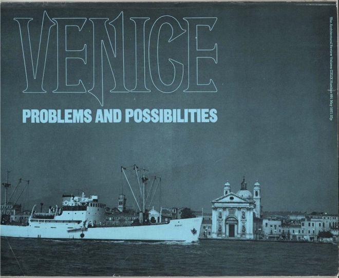
In a 1971 special edition of Architectural Review devoted to the lagoon city author Jan Morris proposes to simply let the city sink. It’s a polemical claim, but one that takes the ambivalences and dilemmata of historic heritage seriously. A different, longer version of the text was printed in the New York Times on July 20, 1975. It is a wonderful piece of polemic and speculative journalism on the city that, according to the words of Jan Morris, “for a thousand years has occupied a unique position in the imagination, the affection and the distaste of all the nations.” Both version of the text are online here (1971) andhere (1975). And in 2023 Catherine Bennett wrote a nice piece for Wired magazine to review Jan Morris original position, which is also online.
Cover from the 1971 special edition of Architectural Review.
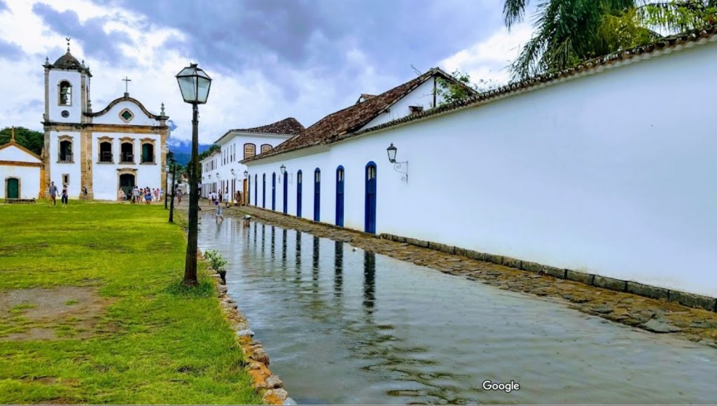
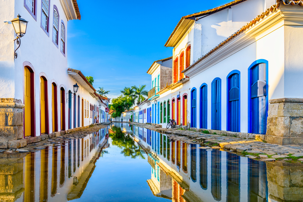
Paraty is a small town and tourist location on Brazil’s Costa Verde, between Rio de Janeiro and São Paulo. Rising as high as 1,300 meters behind the town are tropical forests and mountains. The village was founded in 1597 and established formally as a town by Portuguese colonists in 1667. The region was populated by the Guaianás Indians. Paraty’s historic center has cobbled streets and buildings dating to its time as a port, during the Brazilian Gold Rush around 1700. Since it is located below-sea-level, the streets flood every full-moon at high tide. Instead of keeping the sea water out, the city planners built a sea wall with special openings to let the water flow in and clean the cobble stone streets.
The following excerpt is from an article by Jose Barbedo et al. Full text can be found here.
“The leading Brazilian urban planner Lucio Costa has described Paraty as the city where the ways of the sea and the paths of the earth meet and interlock. This short description synthesizes the unique landscape that surrounds one of the most valuable colonial settlements in South America.
When the first Portuguese settled in this site in the 16th century, the area was composed of wetlands, which were since progressively drained for the construction of the colonial town. The remnants of the floodplain which were not urbanized have been converted for agricultural use, serving as a buffer zone between the city and the mountains. The two river systems flowing into the urban area (Mateus Nunes and Perequê Açu) have steep gradients, bringing rapid discharges of large volumes of storm water onto the floodplain.
The original settlement was planned to cope with regular high tides and common flooding events; the streets were deliberately designed in a “V” shape, sloping down from the curbs towards the center, in order to keep the houses dry while the streets turned into canals. Today, this fragile balance between the city and its natural environment is threatened by unplanned urban expansion, which in turn may also be aggravated by more frequent extreme rainfall events as registered in recent times.”
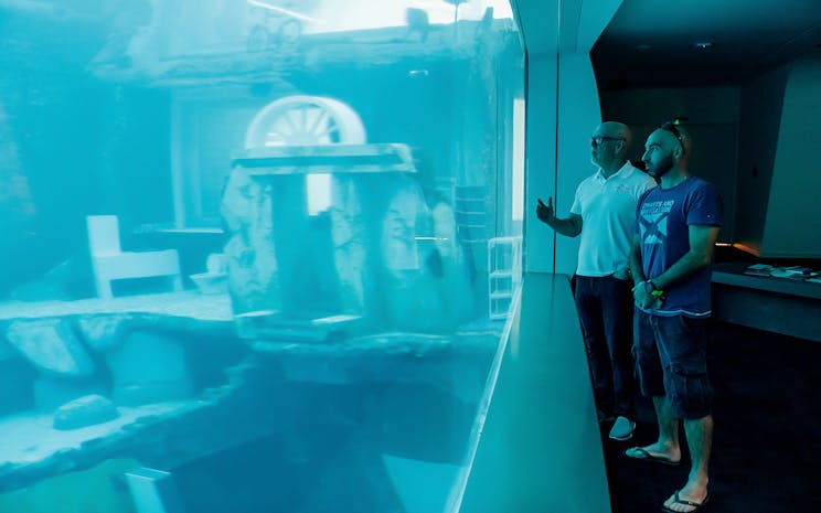
“Take the plunge and explore an abandoned and flooded city, an incredible 60 meters underwater. Experience Deep Dive Dubai – a world of exciting and unique scuba and freediving opportunities,” reads the website of Deep Dive Dubai, a newly opened diving resort. The resort is said to be conveniently located “– 15 minutes from Downtown Dubai and 25 minutes from Dubai International Airport –” and sets the world record for the deepest artificial diving pool, featuring artificial ruins for the divers to explore.
Of course, Deep Dive Dubai, cashes in on the uncanny of a dive among ruins in a city that according to studies from 2010 could very likely be submerged by 2100. Dubai ranks high among the coastal cities most at risk from sea level rise. The “sunken city” appears to be such a vital marketing element, it even has it’s own icon on all webpages of the company, as you can see below:
Artificial ruins are not a new idea. They were already once the rage among landscape architects in the period of romanticism in the 19. century all over Europe. For more info on the cult of ruins, you can read online the publication by Anne Eriksen enticingly titled “The Murmur of Ruins” or check out the wikipedia entry on ruins with images of the garden of the castle Schönbrunn in Vienna.
Cancho Roano is a Spanish archaeological site located in the Extremadura, about 150 kilometers north-west of Cordoba. The architectural structure dates from 550 BC and appears to be some kind of extended ceremonial site, but it’s function and purpose remain unclear. The late archeologist Richard Freund from Hartford University in Connecticut according to Wikipedia “theorizes that Cancho Roano was a ‘memorial city’ designed to serve as a ceremonial representation of the lost city of Tartessos, which, in Freund’s theory, was also Atlantis. Freund argued that a stele found at Cancho Roano displayed an image with concentric circles that matches Plato’s description of Atlantis.”
In the documentary “Finding Atlantis” (2011) Freund explains that the Atlantian refugees essentially built a miniature version of their home city to mourn it’s loss. If Freund was right, the site would be an ancient example of a rather unusual architectural memorial, a memorial for a city lost. I don’t know of any other historic example of a ritual site to mourn a lost city. It would also imply that the community stayed together after the destruction of Atlantis and resettled, something very uncommon at least in Greek antiquity according to historian Holger Sonnabend. In the documentary, Freund is also quoted saying, that there were several similar structures in the Extremadura, all commemorating either the same or several lost cities.
No matter the scientific plausibility, it’s an inspiring thought, that an exiled urban community would build a ceremonial model of their former home in their new settlement.
As this documentary from German TV from 2022 clearly shows, designing floating cities is one thing, wanting to live there is quite another. I guess instinctively we all prefer “stability over floating flexibility”, as director Kristin Siebert says, land over sea, grounded houses over floating houses. As desirable living by the sea might be, living on it, is a different matter.
The film does a fine job connecting and juxtaposing places and communities from the global south and global north, sharing similar fate and trying out similar solutions.
If floating cities are a real future option for communities challenged by climate change like Malé, the capital of the Maledives, we need to look at the socio-cultural and emotional aspects of what makes people feel at home. And that might be essentially the same in the Pacific as in Germany or Holland. Breaking with a culture of habitation of several thousand years is no easy task!
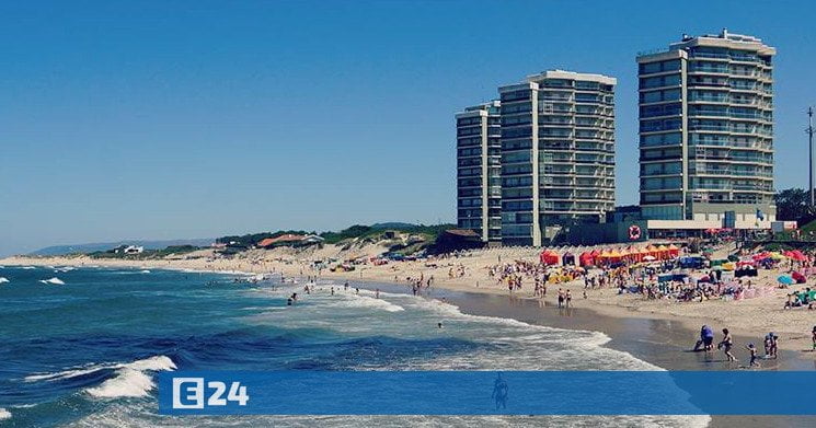
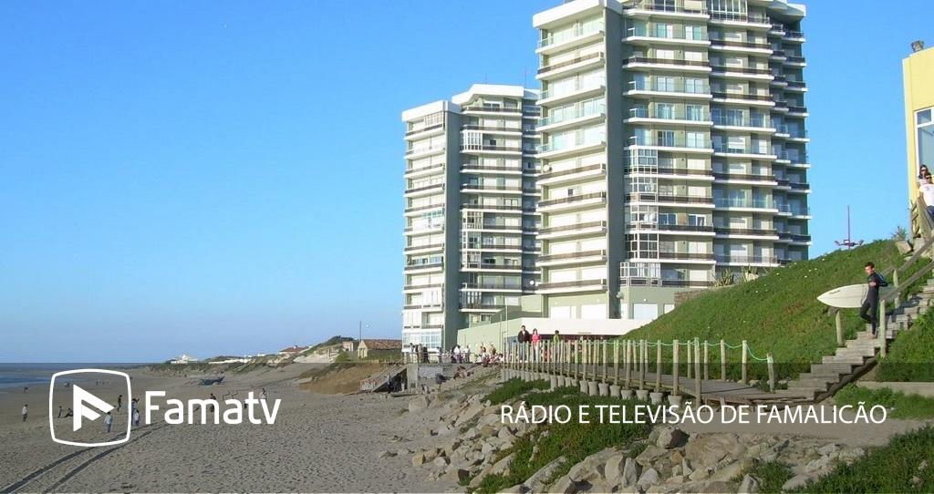
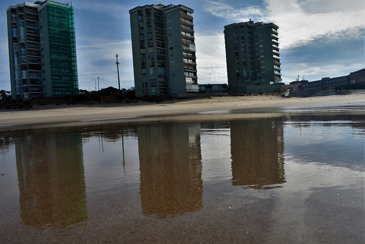
In the north of Portugal, sea lvel rise causes masssive land loss along the Atlantic coast. The building that has become the most emblematic for the situation along Portugal’s coast are the Torres de Ofir, three towers set between the Cavado river and the ocean front in Esposende, about an hour north of Porto. The Portuguese hydrobiologist and researcher at the Abel Salazar Institute Adriano Bordalo e Sá made the following statement which has become much quoted by the press: ” “Se vivêssemos num país a sério, as torres de Ofir há muito teriam sido demolidas / If we were a serious country, the towers would have been demolished long ago.”
Depending on how the photo is taken, the three towers appear more or less vulnerable to the ocean. Some photo journalists have even opted for a tilted perspective, making the scene appear a bit more dramatic. Here is a selection of recent and historic photos. Clearly the Torres de Ofir are an infamous and much publicized example of the kind of problematic coastal architecture in times of rising sea level.


-kTIC-U15011624955535eB-1248x770@Hoy.jpg)