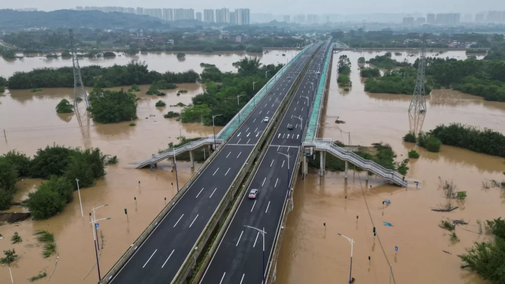
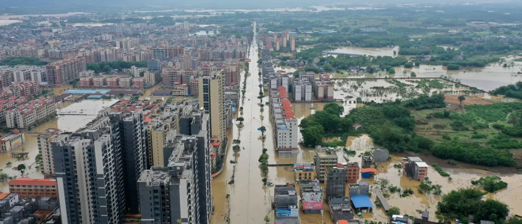
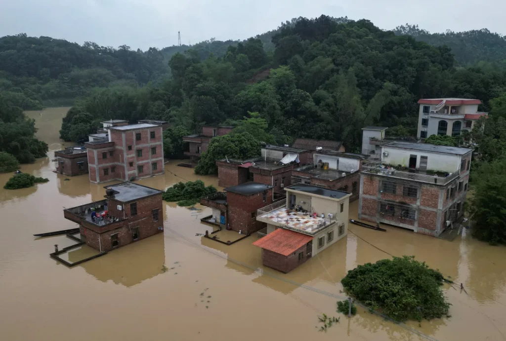
Qingyuan flooded, April 2024

These images are from news reports from the metropolis in the Guangdong province, Southern China. The region experienced massive floodings in April 2024 once more due to intense rain. It’s not a coastal city, instead Qingyuan has been repeatedly flooded by water from the Bei Jiang river.

Power and disaster

In Greek and Roman Antiquity extreme weather events and natural disasters like droughts, earthquakes and floods were a frequent occurrence. They also offered important stages for the display of political power. Political leaders would rush to the occasion to help the population out of their hardship and make sure that other powers and posterity notice. In fact, according to historian Holger Sonnabend, political power was recognized mainly by the ability to help and rebuild. This was even sometimes used by suffering cities to get as much support as possible from rivaling politicians.

Accompanying the imperative of help was the public display of grieve. Compassion was expected of those in power and it was common for leaders to require historians to write up their grieve in dramatic ways. Here is an example from the 7. Century CE by Georgios Kedrenos, who describes in retrospect the expression of grieve of emperor Justinian upon the earth quake in Antiochia in May 526.

“He threw aside his crown and his imperial clothes, and, dressed in dirty rags, wept for several days, and even on feast days he entered the church in pitiful robes because he could not bear to put on any signs of his power.”

The educator and historian Libanius (314 – 392 CE) on the other hand wrote in an eulogy on emperor Julian that the earth itself mourned with an earth quake and several tsunamis in the Mediterranean in 365 CE the loss of this great emperor the year before.

“Earth truly has been fully sensible of her loss, and has honoured the hero by an appropriate shearing off of her tresses, shaking off, as a horse doth his rider, so many and such great cities. In Palestine several; of the Libyans all and every one. Prostrate lie the largest towns of Sicily, prostrate all of Greece save one; the fair Nicaea lies in ruins; the city, pre-eminent in beauty, totters to her fall, and has no confidence for the time to come! These are the honours paid to him by Earth, or if you choose, by Neptune himself; but on the part of the Seasons, famines and pestilences, destroying alike man and beast, just as though it were not lawful for creatures upon earth to enjoy health now that he has departed! What wonder then is it, if such being the state of things, many a one, like myself, deems it a loss not to have died before!”

(full text in english)

For the disaster of 365 in the Mediterranean see also this post.

Noah’s Ark on a silver coin


This silver coin was printed in 1737 to celebrate the end of the flood and famine in Silesia in 1736/1737. The front shows the biblical scene of the dove returning to Noah’s Ark with a German text from Psalm 37, which translates as “Put your life in the hands of the Lord; have faith in him and he will do it.” The back side depicts a sacrifice and the Ark on Mt. Ararat in the back.

Ammianus Marcellinus on the tsunami of 365 CE

This is the famous section from the 28. book of the “Res Gestae”, the history written by Roman historian Ammianus who lived from around 330 – 400 CE. It describes the earthquake and tsunami of July 21. 365 CE which shook the whole Mediterranean. The scene described by Ammianus is most likely set at the coast of Sicily. As the author mentions, areas as far as the Egyptian shore were affected by tsunamis resulting from the earthquake which had its epicenter near Crete. The city of Alexandria was heavily destroyed and the event was publicly remembered in the city for at least a hundred years as the “Day of Fear”. As Egyptian researcher Yasmine Hussein explained to me, it takes less than 40 minutes for a tsunami from Crete to arrive in Alexandria.

“For a little after daybreak, preceded by heavy and repeated thunder and lightning, the whole of the firm and solid earth was shaken and trembled, the sea with its rolling waves was driven back and withdrew from the land, so that in the abyss of the deep thus revealed men saw many kinds of sea-creatures stuck fast in the slime; and vast mountains and deep valleys, which Nature, the creator, had hidden in the unplumbed depths, then, as one might well believe, first saw the beams of the sun.

Hence, many ships were stranded as if on dry land, and since many men roamed about without fear in the little that remained of the waters, to gather fish and similar things, with their hands, the roaring sea, resenting, as it were, this forced retreat, rose in its turn; and over the boiling shoals it dashed mightily upon islands and broad stretches of the mainland, and levelled innumerable buildings in the cities and where else they were found; so that amid the mad discord of the elements the altered face of the earth revealed marvellous sights.

For the great mass of waters, returning when it was least expected, killed many thousands of men by drowning; and by the swift recoil of the eddying tides a number of ships, after the swelling of the wet element subsided, were seen to have foundered, and lifeless bodies of shipwrecked persons lay floating on their backs or on their faces. Other great ships, driven by the mad blasts, landed on the tops of buildings (as happened at Alexandria), and some were driven almost two miles inland, like a Laconian ship which I myself in passing that way saw near the town of Mothone, yawning, apart through long decay.”

Original online source.

Thanks to Holger Sonnabend for the lead!

Bhola Cyclone of 1970

The 1970 Bhola cyclone (also known as the Great Cyclone of 1970) was a devastating tropical cyclone that struck East Pakistan (present-day Bangladesh) and India’s West Bengal on November 12, 1970. It remains the deadliest tropical cyclone ever recorded and one of the world’s deadliest humanitarian disasters. At least 300,000 people died in the storm, possibly as many as 500,000, primarily as a result of the storm surge that flooded much of the low-lying islands of the Ganges Delta. Bhola was the sixth and strongest cyclonic storm of the 1970 North Indian Ocean cyclone season.

Yajnaseni Chakraborty writes in an online article, that the cyclone also formed a new nation: Bangladesh. Since the 1940’s East-Bengal had been a part of Pakistan, officially called East-Pakistan, and was governed by the central Pakistani military government:
“A few days after the disaster, with East Pakistanis seething in anger against the West Pakistan government, political leader Maulana Abdul Hamid Khan Bhashani held a rally at Dhaka’s old Paltan Maidan, famously declaring, “Ora keu aseni (none of them turned up),” and went on to say, “From today, we are independent East Bengal, no longer East Pakistan”. The next day, says Haider, ‘Ora keu aseni’ was printed as a banner headline in the newspaper ‘Pakistani Khabar’, controlled by the Pakistan government’s Press Trust.”

The following Bengal War in 1971 took another 3 million Bengali lives, according to the Bangladesh government. In August 1971 the nation was finally declared independent. Today Bangladesh is regarded as one of those countries with a highly effective disaster protection program.

The Bride and the Sink Hole

The city of Alexandria once had an extensive network of water cisterns below ground that distributed drinking water from a channel connecting the river Nile south-east of the city with the city’s harbor in the west. This was vital for the survival of the population as the Nile flood brought sweet water to the city only once in the summer months. The water needed to be stored for the remaining year and the deep cisterns served that purpose. As the „city of layers“, as it is often referred to, grew and layers upon layers of streets and buildings were added, the cisterns underground would collapse from time to time, creating sink holes and cracks in the streets. In some areas, sea water dissipates into the ground, further enhancing the erosion of the structure.

The artist Islam Shabana told me the following story: In 1973 a young, newly wed woman fell into a sink hole that suddenly opened up under her. When people came to her rescue she disappeared completely into the abyss. Rescue teams climbed after her but never found the body.

The disappearance of a young woman in broad daylight and right before the eyes of the people is of course the stuff for an enduring urban legend. One popular story speculates that she was abducted by a love-struck Jinn who was enraged by her marriage to another man.

The woman is simply referred to by Alexandrians as „The Bride“. Alexandria itself is called „The Bride of the Mediterranean“ and one of Alexandria’s emblematic figures is the mermaid, which in Arab means „Bride of the Sea“. And what makes this story for Alexandrians even more meaningful is, that in the same street the Bride disappeared another body disappeared too: the body of the city’s founder Alexander the Great. As was confirmed to me by Islam Shabana, Al Naby Danyal (Prophet Daniel Street) is the most probable location of the shrine that held the emperor’s body, referred to as Soma, meaning simply „The Body“. The building and Alexander’s remains are lost and it is unclear what happened to them. Historian Islam Issa writes, that most probably it was situated on the corner of Al Naby Danyal and Fuad Street and might still be there, only underground.

Today even more than in the 1970s, sink holes are appearing everywhere in the city, especially in the winter months. The ground below Alexandria is hollowed like a Swiss cheese, as historian Kathrin Machinek explained to me. The cisterns have not been in use for decades and there are so many, that it is impossible to say, where and when the next one will collapse. The sea level rise in the Mediterranean and land subsidence due to the incessant building activity above ground makes matters worse.

Prophet Daniel Street, freshly paved, on the corner of Fuad Street in April 2024.

Thanks to Islam Shabana for the lead!

Heracles, the first hydraulic engineer

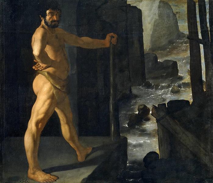
According to historian Terje Tvedt the Greek god and hero Heracles derived from a much older Egyptian hero of similar name. The now submerged city Heracleion off the coast of the Nile delta was named after the god and Heracles plays a central role in the ancient literature of the region. The historian Diodorus of Sicily, who lived in the 1st. Century BCE, recounts Heracles’ story in detail. Among the many feats he describes, several are connected to hydrology. The most famous one is of course from the Twelve Labors of Heracles. Here is the original passage from Diodorus’ History:

“He received a Command from Eurystheus to cleanse the stables of Augeas, and to do this without the assistance of any other man. These stables contained an enormous mass of dung which had accumulated over a great period, and it was a spirit of insult which induced Eurystheus to lay upon him the command to clean out this dung. Heracles declined as unworthy of him to carry this out upon his shoulders, in order to avoid the disgrace which would follow upon the insulting command; and so, turning the course of the Alpheius river, as it is called, into the stables and cleansing them by means of the stream, he accomplished Labour in a single day, and without suffering any insult.”

Hercules the engineer as seen by Francisco de Zuraban

The story is reminiscent of the way ancient Egyptian society used the annual floods of the river Nile to fertilize but also clean the farm land along the river banks.

Here are two other hydraulic engineering feats:

“When Heracles arrived at the farthest points of the continents of Libya and Europe which lie upon the ocean, he decided to set up these pillars to commemorate his campaign. And since he wished to leave upon the ocean a monument which would be had in everlasting remembrance, he built out both the promontories, they say, to a great distance; consequently, whereas before that time a great space had stood between them, he now narrowed the passage, in order that by making it shallow and narrow​ he might prevent the great sea-monsters from passing out of the ocean into the inner sea, and that at the same time the fame of their builder might be held in everlasting remembrance by reason of the magnitude of the structures. Some authorities, however, say just the opposite, namely, that the two continents were originally joined and that he cut a passage between them, and that by opening the passage he brought it about that the ocean was mingled with our sea. On this question, however, it will be possible for every man to think as he may please.”

“A thing very much like this he had already done in Greece. For instance, in the region which is called Tempê, where the country is like a plain and was largely covered with marshes, he cut a channel through the territory which bordered on it, and carrying off through this ditch all the water of the marsh he caused the plains to appear which are now in Thessaly along the Peneius river. But in Boeotia he did just the opposite and damming the stream which flowed near the Minyan city of Orchomenus he turned the country into a lake and caused the ruin of that whole region. But what he did in Thessaly was to confer a benefit upon the Greeks, whereas in Boeotia he was exacting punishment from those who dwelt in Minyan territory, because they had enslaved the Thebans.”

Full text in english translation

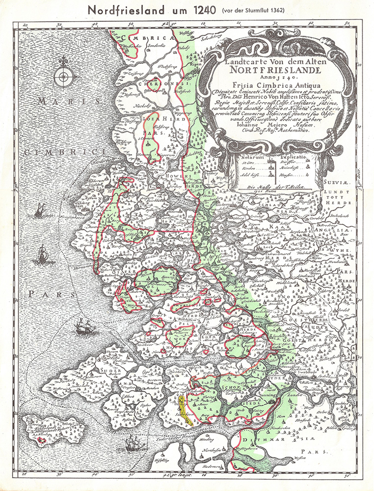
The coast of North Frisia over the last nine centuries

Storm surge events on the North Sea

12/26/838
First documented storm surge in the North Sea; Approximately 2,500 deaths in what is now the Netherlands.

2/17/1164
First Julian flood: 20,000 dead; First collapse of the Jade Bay, major damage in the Elbe area.

1/16/1219
First Marcellus flood: 36,000 dead: major floods also in the Elbe area; first conveyed eyewitness report.

12/28/1248
Allerkindslein flood: High loss of human life. The historic Elbe island of Gorieswerder is divided into several parts.

12/14/1287
Lucia Flood: Beginning of the formation of the Dollart, 50,000 dead.

11/23/1334
Clemens Flood: Expansion of the Jade Bay.

1/16/1362
Second Marcellus Flood, Grote Manndranke: 100,000 dead: first collapse of the Dollart, expansion of Leybucht, Hariebucht, Jade Bay and Eider Estuary, sinking of large parts of North Frisia.

10/09/1374
First Dionyslus flood: Largest extent of the Leybucht up to the city of Norden, sinking of the village of Westeel near Norden.

9/10/1377
Second Dionysiusflut: Dikes near Lütetsburg and Bargebur
torn, the waves hit the walls of the Dominican monastery in Nord.

11/21/1412
Cacilien flood: An entire village at the mouth of the Este was destroyed, and the Elbe island of Hahnöfersand was separated from the mainland.

11/1/1436
Allerhelligen flood: Flooding on the entire North Sea coast, especially in Eiderstedt and Nordstrand.

1/6/1470
Epiphany Flood: Flooding in Eiderstedt, no permanent land losses.

09/26/1509
Cosmas and Damian flood: Breakthrough of the Ems
near Emden, largest expansion of the Dollart, last expansion of the Jade Bay to the northwest.

01/16/1511
Antonius flood, ice flood: breakthrough between Jade and Weser.

10/31 and 11/1/1532
Third All Saints Flood: Several thousand dead in North Frisia, first peak value recorded in the church of Klibüll; Sinking of Osterbur and Ostbense in East Frisia.

11/01/1570
Fourth All Saints Flood: Flooding of the marshes from Flanders to Eiderstedt: large dike breaches in the Altes Land as well as in the Vier- und Marschenlanden; Sinking of the villages of Oldendorf and Westbense near Esens: 9,000 to 10,000 dead between Ems and Weser. High tide mark at the Suurhusen church at NN +4.40 m.

2/26/1625
Carnival flood: An ice flood, dike breaches and major damage in East Frisia and Oldenburg, in the Altes Land and Hamburg, many dikes breaches on Jade and Weser.

10/11/1634
Second Grote Manndranke: Strand Island sinks; What remains are the islands of Nordstrand and Pellworm; at least 8,000 dead.

2/22/1651
Petri flood: “Dane chains” broken on Juist and Langeoog, Dornumersiel was destroyed, there were dike breaches on the mainland.

11/12/1686
Martin’s Flood: Severe damage to dikes from the Netherlands to the Elbe.

12/24 to 12/25/1717
Christmas flood: 11,150 dead from Holland to the Danish coast: the largest storm surge known to date with flooding and devastation of enormous proportions.

12/31/1720 to 01/01/1721
New Year’s flood: higher than Christmas flood; Destruction of the dikes that were poorly repaired after 1717; Sinking of the villages Bettewehr II and Itzendorf

2/3 to 2/4/1825
February flood: 800 dead; There were many dike breaches along the coast and severe loss of dunes on the islands. Highest storm surge on the Elbe until 1962.

1/1 to 1/2/1855
January flood: Heavy destruction on the East Frisian Islands, storm surge mark on Norderney at NN +4.26 m.

3/13/1906
March flood: highest storm surge recorded to date on the East Frisian coast.

1/31 to 2/1/1953
Dutch flood: worst natural disaster of the 20th century in the North Sea area. In the Netherlands approx. 1,800 dead, England and Belgium more than 2,000 dead; Total damage more than €500 million: no major damage to the German coast, but an impetus to check the dikes.

2/16 to 2/17/1962
February storm surge, Second Julian flood: 340 dead, 19 of them in Lower Saxony, approx. 28,000 apartments or houses damaged and 1,300 completely destroyed; highest storm surge to date East of the Jade with 61 dike breaches in Lower Saxony; The Elbe area and its tributaries were particularly affected.

1/3/1976
January flood: highest storm surge to date on almost all pegs on the German North Sea coast: numerous dike breaches in Kehdingen and the Haseldorfer Marsch.

11/24/1981
November flood: Highest peak water level in North Frisia with NN +4.72 m at the Dagebüll gauge.

1/28/1994
January flood: Highest peak water levels on the Ems with NN +4.75 m at the Weener gauge and on the Wese with NN +5.33 m at the Vegesack gauge.

12/3/1999
Anatol: short-term increase with very high water levels in the entire North Sea region; The storm subsided before the astronomical flood occurred in Cuxhaven, otherwise the values ​​of 1976 had been exceeded in the Elbe area.

11/01/2006
Fifth All Saints Flood: Very severe storm surge with water levels exceeding the 1994 levels in the Ems area, dike collapses on the East Frisian islands of Juist, Langeoog and Wangerooge…

This list was assembled by Christian von Wissel of Bremer Zentrum für Baukultur. It was part of the exhibition “Deichstadt #1” in spring 2024.
Sturmflutereignisse an der Nordsee

26.12.838
Erste dokumentierte Sturmflut an der Nordsee; ca. 2500 Tote im Gebiet der heutigen Niederlande.

17.02.1164
Erste Julianenflut: 20.000 Tote; erster Einbruch der Jade, große Schäden im Elbegebiet.

16.01.1219
Erste Marcellusflut: 36.000 Tote: große Überflutungen auch im Elbegebiet; erster überieferter Augenzeugenbericht.

28.12.1248
Allerkindsleinflut: Hohe Verluste an Menschenleben Zertrennung der historischen Elbinsel Gorieswerder in mehrere Teile.

14.12.1287
Luciaflut: Beginn der Bildung des Dollarts, 50.000 Tote.

23.11.1334
Clemensflut: Erweiterung des Jadebusens.

16.01.1362
Zweite Marcellus-Flut, Große Manndränke: 100.000 Tote: erster Einbruch des Dollart, Erweiterung von Leybucht, Hariebucht, Jadebusen und Eidermündung, Untergang von großen Teilen Nordfrieslands.

09.10.1374
Erste Dionyslusflut: Größte Ausdehnung der Leybucht bis zur Stadt Norden, Untergang des Dorfes Westeel bei Norden.

09.10.1377
Zweite Dionysiustlut: Deiche bei Lütetsburg und Barge-
bur zerrissen, die Wellen schlugen an die Mauern des Dominikanerklosters zu Norden.

21.11.1412
Cacilienflut: An der Estemündung wurde ein ganzes Dorf vernichtet, die Elbinsel Hahnöfersand wurde vom Festland abgetrennt.

01.11.1436
Allerhelligenflut: Übertflutungen an der gesamten Nordseoküste, insbesondere in Eiderstedt und Nordstrand.

06.01.1470
Dreikönigsflut: Überflutungen in Eiderstedt, keine bleibenden Landverluste.

26.09.1509
Cosmas- und Damianflut: Durchbruch der Ems
bei Emden, größte Ausdehnung des Dollarts, letzte Erweiterung des Jadebusens nach Nordwesten.

16.01.1511
Antoniusflut, Eisflut: Durchbruch zwischen Jade und Weser.

31.10/01.11.1532
Dritte Allerheiligenflut: Mehrere tausend Tote in Nordfriesland, erste Höhenmarke des Scheitelwertes überliefert in der Kirche von Klibüll; Untergang von Osterbur und Ostbense in Ostfriesland.

01.11.1570
Vierte Allerheiligenflut: Überflutung der Marschen von Flandern bis Eiderstedt: große Deichbrüche im Alten Land sowie in den Vier- und Marschenlanden; Untergang der Dörfer Oldendorf und Westbense bei Esens: 9.000 bis 10.000 Tote zwischen Ems und Weser. Flutmarke an der Kirche Suurhusen bei NN +4,40 m.

26.02.1625
Fastnachtsflut: Eine Eisflut, Deichbrüche
und große Schäden in Ostfriesland und Oldenburg, im Alten Land und Hamburg, viele Ausdeichungen an Jade und Weser.

11.10.1634
Zweite Manndränke: Insel Strand geht unter; Reste sind die Inseln Nordstrand und Pellworm; mind. 8.000 Tote.

22.02.1651
Petriflut: Auf Juist und Langeoog wurden Dänenketten durchbrochen, Dornumersiel wurde zorstört, es gab Deichbrüche am Festland.

12.11.1686
Martinsflut: Schwere Deichschäden von den Niederlanden bis zur Elbe.

24./25.12.1717
11.150 Tote von Holland bis zur dänischen Küste: größte bis dahin bekannte Sturmflut mit Überflutungen und Verwüstungen ungeheuren Ausmaßes.

31.12.1720/01.01.1721
Neujahrsflut: höher als Weihnachtsflut; Zerstörung der nach 1717 notdürftig reparierten Deiche; Untergang der Dörfer Bettewehr II und Itzendorf

03./04.02.1825
Februarflut: 800 Tote; entlang der Küste kam es zu vielen Deichbrüchen und schweren Dünenverlusten auf den Inseln. Höchste Sturmflut an der Elbe bis 1962.

01./02.01.1855
Januarflut: Schwere Zerstörungen auf den Ostfriesischen Inseln, Sturmflutmarke auf Norderney bei NN +4,26 m.

13.03.1906
Märzflut: höchste bis dahin festgestellte Sturmflut an der ostfriesischen Küste.

31.01./01.02.1953
Hollandflut: schwerste Naturkatastrophe des 20. Jahrhunderts im Bereich der Nordsee. In den Niedertan den (ca. 1800 Tote), England und Belgien mehr als 2000 Tote; Gesamtschaden mehr als 500 Mio. €: keine größeren Schäden an der deutschen Küste, jedoch Anstoß, die Deiche zu überprüfen.

16./17.02.1962
Februarsturmflut 62, 2. Julianenflut: 340 Tote, davon 19 in Niedersachsen, ca. 28.000 Wohnungen bzw. Häuser beschädigt und . 1.300 vollg zerstört; höchste bisherige Sturmflut Ostlich der Jade mit 61 Deichbrüchen in Niedersachsen; betroffen war vor allem das Elbegebiet mit seinen Nebenflüssen.

03.01.1976
Januarflut: bis heute höchste Sturmflut an nahezu allen Pegein der deutschen Nordseeküste: zahlreiche Deichbrüche in Kehdingen und der Haseldorfer Marsch.

24.11.1981
Novemberflut: Höchste Scheitelwasserstände in Nordfriesland mit NN +4,72 m am Pegel
Dagebüll.

28.01.1994
Januarflut: Höchste Scheitelwasserstände an Ems mit NN +4,75 m am Pegel Weener sowie an der Wese mit NN
+5,33 m am Pegel Vegesack.

03.12.1999
Anatol: kurzfristiger Anstieg mit sehr hohen Wasserständen im gesamten Nordseegebiot; Abflauen des Sturms vor Eintritt des astronomischen Hochwassers in Cuxhaven, andornfalls waren im Elbegebiet die Werte von 1976
überschritten worden.

01.11.2006
Fünfte Allerheiligenflut: Sehr schwere Sturmflut mit Überschreiten der Pegelwerte von 1994 im Bereich der
Ems, Deichabbrüche auf den ostfriesischen Inseln Juist, Langeoog und Wangerooge …