The Great Pacific Plastic Patch

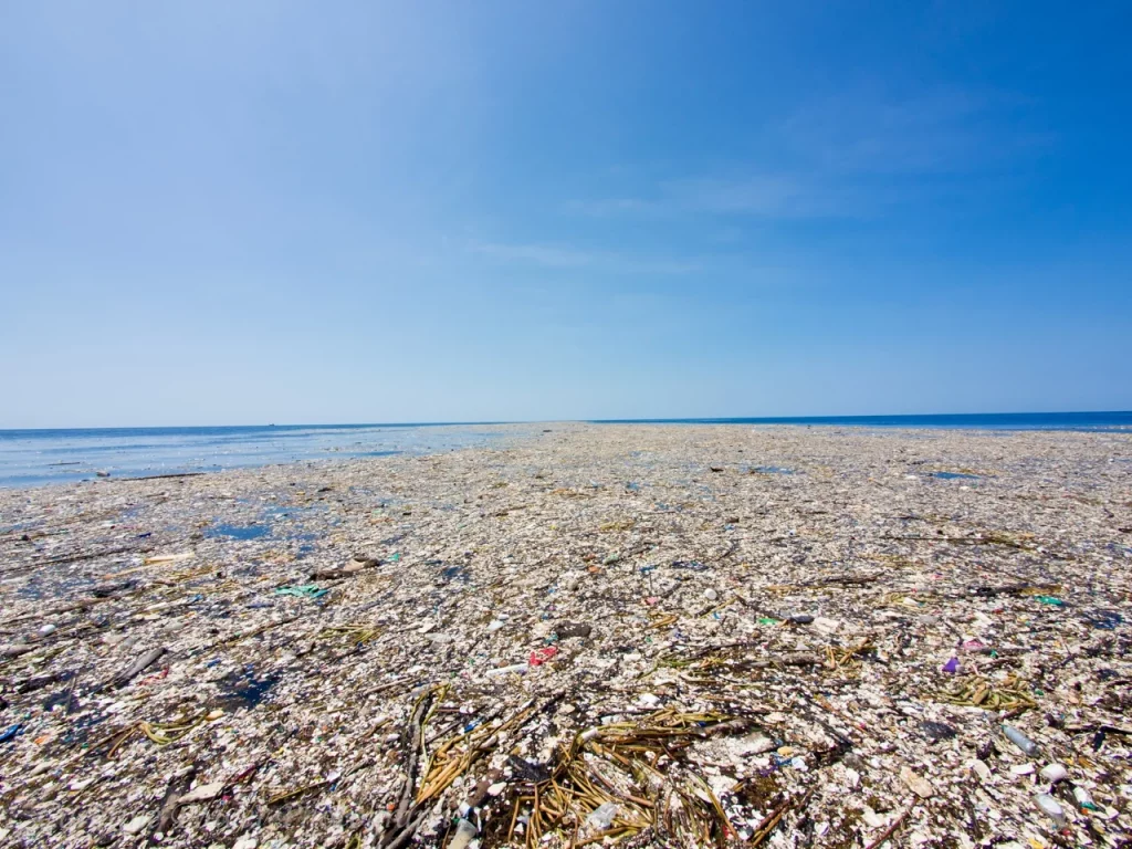
When I read about this assembly of plastic garbage, I was inevitably reminded of stories out of the saga “Erik the Red” or the Irish Legend of Saint Brendan. In other words, it has everything for being a modern myth, a contemporary fairy tale: A gigantic new island that appeared in the pacific ocean suddenly. It’s size is questionable. It is floating, so it’s exact position is also questionable. It is very hard to get to and it is dangerous.

Take for example this excerpt from National Geographic:

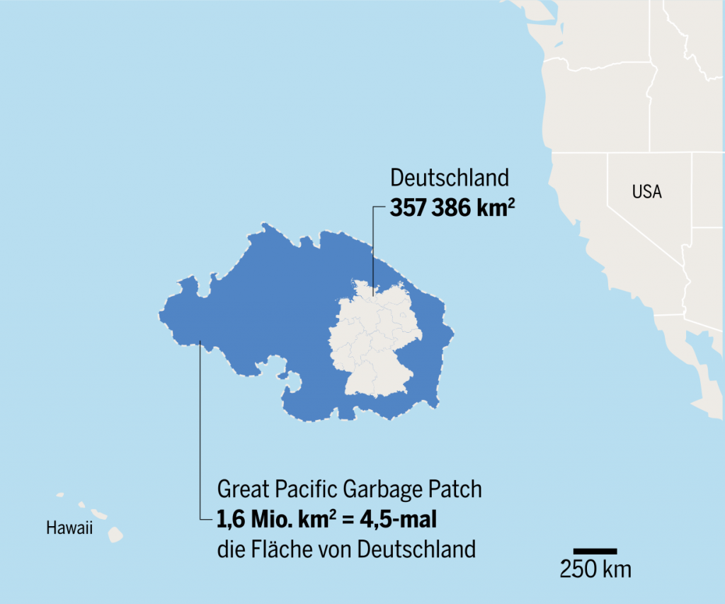
“Many expeditions have traveled through the Great Pacific Garbage Patch. Charles Moore, who discovered the patch in 1997, continues to raise awareness through his own environmental organization, the Algalita Marine Research Foundation. During a 2014 expedition, Moore and his team used aerial drones, to assess from above the extent of the trash below. The drones determined that there is 100 times more plastic by weight than previously measured. The team also discovered more permanent plastic features, or islands, some over 15 meters (50 feet) in length.”

And a nameless Captain is quoted: “Fishermen shun it because its waters lack the nutrients to support an abundant catch. Sailors dodge it because it lacks the wind to propel their sailboats.”

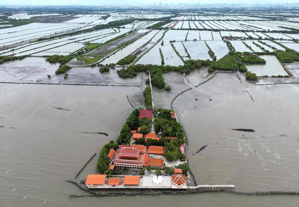
So while islands like Tuvalu and cities like Jakarta are projected to sink beneath the sea in the next 100 years to join Atlantis and the many, many sunken islands and cities of our mythology, new and fascinating islands appear.

I wonder if the Great Pacific Plastic Patch too will become the stuff of songs and poetry in 200 years from now.

The temple of Khun Samut Chin

This aerial photograph taken on June 14, 2023 shows the Buddhist temple called Samut Trawat of Ban Khun Samut Chin, a coastal village 10 km south of Bangkok, as seen in the background. At Samut Chin, the ocean has approached by 2 kilometers in the past 60 years. While all other buildings were abandoned and the population settled about a kilometer further inland, the monks lifted the building by two meters and it is now only reachable by way of a small wooden footbridge.
The religious site and the monks caring for it and protecting it against the rising sea level has become emblematic of the situation in the Bangkok Bay. Here’s another foto from 2015 that shows the inside of the temple. You can clearly see how the floor of the room was raised and the water marks on the cement walls.

I have already posted several other images of inundated religious sites across Asia here and here. The most famous one maybe being the Wal Adhuna mosque just outside the sea wall in North-Jakarta. Temples and Mosques have a special value as safe spaces and centers of communities, it is thus no surprise that they become focus points of imagining and expressing our ecological fears.

Here are two articles from 2015 and 2023 about the fate of Ban Khun Samut Chin with more background information.

Serempak of the Bajau People

This is the traditional festive head gear worn by Bajau women. The Bajau, a formerly nomadic people now mostly home to Malaysia, Indonesia and the Philippines, live by and from the sea and have recently gained recognition for a genetic trait that allows them to dive deeper and for longer time stretches than any other ethnic group. They are often referred to as Sea People and this traditional head gear seems to symbolize this. I could not find any interpretation of the shape, but they appear to me like ships or tail fins of sea mammals or mermaids – or all three.

Sea Peoples

The Orang Laut, who mainly settle in Singapore, Malaysia and Indonesia, the Moken in Thailand, and the Sama-Bajau who mainly live in East-Malaysia and the Philippines are ethnic groups that have a seaborne or amphibian lifestyle and culture.

The Malayan name Orang Laut literally translates as Sea People. The Moken are also called chao nam in Thai, meaning “people of the water”. Both the Moken and the Bajau are nomadic societies, moving between islands along various coasts, some families even spending long periods of the year living on their boats. The largest group, the Bajau, are said to exist for over 1.000 years. I did not know that there were nomadic sea faring societies like that at all. Apparently several Bajau myths exist that explain how and why they first adopted their nomadic lifestyle.

This picture of a “typical” settlement of Bajau in the Philippines I find particularly striking for the isolation of the individual buildings and the lack of any visible land close by:

Traditionally these societies lived from fishing but there are anthropological indications that at least the Bajau were once an agricultural society. Their traditional lifestyles center around fishing and harvesting sea plants and the often nomadic lifestyle make them very vulnerable to environmental damage, economic and political exploitation and oppression. Many of them have meanwhile settled on land and further off the sea coast for better employment opportunities.

This image of a Bajau boat fair, called Regatta Lepa, shows a striking similarity to the festival of Marriage to the Sea that is celebrated in far away Venice, Italy. (see my blog entry)

Two other links are noteworthy here:
In the Boxing Day Tsunami of 2004, the Moken people who lived around the Surin Islands of Thailand were able to predict the events quite accurately which allowed them to warn and protect the island population. However in other places, Moken suffered severe devastation to housing and fishing boats by the tsunami. (see related scientific report on indigenous knowledge and disaster here.)

These ethnic groups are probably the inspiration to many myths about sea people in the region. As biological studies have recently revealed, the Moken and Bajau show genetic traits that allow better under water vision and a significantly greater ability to dive and hold their breath. These sea people are probably the closest humanity gets to mythical figures like “aqua men”, “frog men” or “mermaids”. (See for example the Filippino movie “Beyond Atlantis” from 1973.)

Rear View

An image from the movie “The Wave” from 2015.


In “Being EcologicalTim Morton wonders about the prevalent mode of climate writing, which he calls “information dump”, “dumping massive platefuls of facts on to us” over and over again. Morton wonders, why we do that and finds the following analogy:

“Imagine that we are dreaming. What kind of dream would it be where the characters and plot vary, sometimes significantly, but the overall impact—where the dream leaves us, its basic color or tone or point of view (or what have you) —remains the same? There is definitely an analogy from the world of dreaming: these are the trauma dreams of sufferers of post-traumatic stress disorder (PTSD).” According to Sigmund Freud, Morton writes, “the PTSD sufferer is simply trying to install herself, through her dreams, at a point in time before the trauma happened. Why? Because there is some safety or security in being able to anticipate. Anticipatory fear is far less intense than the fear you experience when finding yourself, all of a sudden, in the middle of a trauma. If you think about it, traumas by definition are things that you find yourself in the middle of—you can’t sneak up on them from the side or from behind, and that’s why they’re traumatic. You just suddenly find yourself in a car crash, for instance. If you had been able to anticipate, you might have been able to swerve out of the way.”
“By analogy, then,” Morton concludes, “information dump mode is a way for us to try to install ourselves at a fictional point in time before global warming happened. We are trying to anticipate something inside which we already find ourselves.”

The Loen Rock Slides in Norway in 1905 and 1936

Just 31 years lie between two disasters of the same nature along the shores of a lake in Western Norway destroying twice the two lakeside villages.

Lake Lovatnet is considered one of the most beautiful lakes in Norway. In the first decade of the 1900s and again in the 1930s large fissures in the rock formation above the lake appeared and eventually rocks repeatedly fell into the lake. In 1905 a massive piece of the mountainside loosened and fell into the lake, producing waves of up to 40 meters in height that completely destroyed the two farm villages on the shore. “61 people lost their lives, half the population of Bødal and Nesdal together. Only ten were ever found.”

The villages were rebuilt, only a little bit higher up the shore. In 1936 daily rock falls happened again before eventually in September that year “one million cubic meters of rock fell down from 800 m height into Lake Lovatnet, pushing up the water and creating three waves; the highest a more than 74 meters high.” The two towns were once again completely destroyed.

Only a hundred kilometers away in a fjord called Tafjord the same thing happened in 1934: a massive piece of rock fell off the mountianside and sent a tsunami wave 17 meters high, reaching up to 300 meters inwards land, crushing houses and other buildings, moving large boats inwards land and killing 23 people.

This threat of rock slides resulting in tsunamis and floodings is common to this region of Norway. In 2015 director Roar Uthaug made a film based on the assumption that a similar event is expected to occur anytime in the future on the Åkerneset mountain, not far from Tarfjord. The movie entitled “The Wave” was so successful, two consecutive films were produced in 2018 and 2022.

The village of Bodal after the Loen Rock Slide. Click on the image for online source.
Image from the movie “The Wave”.
The fjord today. Click on the image for online source.
Image from the movie “The Wave”.

There is an excellent article about the Loen disasters by Christer Hoel online here. The quotes in my post are all from his text. I used another image from the movie here.

“Let Venice sink.”

In a 1971 special edition of Architectural Review devoted to the lagoon city author Jan Morris proposes to simply let the city sink. It’s a polemical claim, but one that takes the ambivalences and dilemmata of historic heritage seriously. A different, longer version of the text was printed in the New York Times on July 20, 1975. It is a wonderful piece of polemic and speculative journalism on the city that, according to the words of Jan Morris, “for a thousand years has occupied a unique position in the imagination, the affection and the distaste of all the nations.”
Both version of the text are online here (1971) and here (1975). And in 2023 Catherine Bennett wrote a nice piece for Wired magazine to review Jan Morris original position, which is also online.

Cover from the 1971 special edition of Architectural Review.

The Year without a Summer


The 19. Century was not only the century of industrialization, the spark that “set human civilization aflame” (Andri Snaer Magnason). Between 1800 and 1815 half a dozen large volcanic eruptions all across the globe significantly changed the climate in China as well as all across Europe and practically all continents. What followed was “the year without a summer” 1816 which did not only bring massive crop failures as well as floods and resulting famines and other hardships to societies worldwide, it also influenced European culture so profoundly that a whole new era of the arts and philosophy developed that had a lasting impact on all of modern society: Romanticism. 1816 is not such a distant past and the paintings, poems, novels and scientific treaties of that era by Caspar David Friedrich, Lord Byron or Mary Shelley remain central to our cultural canon and identity today. In fact, all these climate change stories and images have been right in front of our eyes, in museums, libraries, on t-shirts and advertisements all along. To understand better what’s ahead of us now, we should seek advise from ourselves just seven generations back.


This is an image of the first page of Lod Byron’s famous poem “Darkness” from summer 1816. The full text of the poem and more information about the impacts of “The Year without a Summer” can be found online.

Lo Sposalizio del Mare – the Marriage to the Sea

Every year at Ascension Day (Ascensione di Cristo, or “Festa della Sensa” as the Venetians say, it is celebrated in May) the Republic of Venice celebrates itself but also it’s intimate relationship to the sea.

In the age of Renaissance the head of state, called the Doge, would be rowed out to the island Sant Elena in a boat. Upon entering the open sea, he would throw a golden ring in to the water as a sign of matrimony to the Mediterranean Sea.

This tradition stopped when the independent republic dissolved in the so called Fall of the Republic in 1797. Since the 1960’s Venice has picked up the tradition and the ritual is enacted anualy by the mayor of Venice.

The tradition is believed to be more then 1.000 years old and probably has origins in even older pagan rituals. There are various related stories and rituals of sacrificial offerings to the sea, often with the intent of making it more lenient for sea travels.

Painting by Canaletto (Giovanni Antonio Canal) from 1745

See the respective Wikipedia article here.

Designing cities below sea level: Paraty, Brazil

Paraty is a small town and tourist location on Brazil’s Costa Verde, between Rio de Janeiro and São Paulo. Rising as high as 1,300 meters behind the town are tropical forests and mountains. The village was founded in 1597 and established formally as a town by Portuguese colonists in 1667. The region was populated by the Guaianás Indians. Paraty’s historic center has cobbled streets and buildings dating to its time as a port, during the Brazilian Gold Rush around 1700. Since it is located below-sea-level, the streets flood every full-moon at high tide. Instead of keeping the sea water out, the city planners built a sea wall with special openings to let the water flow in and clean the cobble stone streets.

The following excerpt is from an article by Jose Barbedo et al. Full text can be found here.

“The leading Brazilian urban planner Lucio Costa has described Paraty as the city where the ways of the sea and the paths of the earth meet and interlock. This short description synthesizes the unique landscape that surrounds one of the most valuable colonial settlements in South America.

When the first Portuguese settled in this site in the 16th century, the area was composed of wetlands, which were since progressively drained for the construction of the colonial town. The remnants of the floodplain which were not urbanized have been converted for agricultural use, serving as a buffer zone between the city and the mountains. The two river systems flowing into the urban area (Mateus Nunes and Perequê Açu) have steep gradients, bringing rapid discharges of large volumes of storm water onto the floodplain.

The original settlement was planned to cope with regular high tides and common flooding events; the streets were deliberately designed in a “V” shape, sloping down from the curbs towards the center, in order to keep the houses dry while the streets turned into canals. Today, this fragile balance between the city and its natural environment is threatened by unplanned urban expansion, which in turn may also be aggravated by more frequent extreme rainfall events as registered in recent times.”