Heracles, the first hydraulic engineer

According to historian Terje Tvedt the Greek god and hero Heracles derived from a much older Egyptian hero of similar name. The now submerged city Heracleion off the coast of the Nile delta was named after the god and Heracles plays a central role in the ancient literature of the region. The historian Diodorus of Sicily, who lived in the 1st. Century BCE, recounts Heracles’ story in detail. Among the many feats he describes, several are connected to hydrology. The most famous one is of course from the Twelve Labors of Heracles. Here is the original passage from Diodorus’ History:

“He received a Command from Eurystheus to cleanse the stables of Augeas, and to do this without the assistance of any other man. These stables contained an enormous mass of dung which had accumulated over a great period, and it was a spirit of insult which induced Eurystheus to lay upon him the command to clean out this dung. Heracles declined as unworthy of him to carry this out upon his shoulders, in order to avoid the disgrace which would follow upon the insulting command; and so, turning the course of the Alpheius river, as it is called, into the stables and cleansing them by means of the stream, he accomplished Labour in a single day, and without suffering any insult.”

Hercules the engineer as seen by Francisco de Zuraban

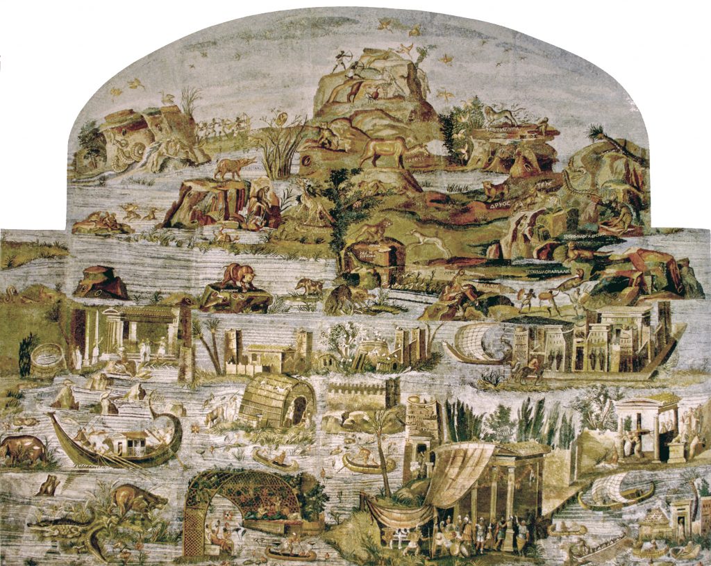
The story is reminiscent of the way ancient Egyptian society used the annual floods of the river Nile to fertilize but also clean the farm land along the river banks.

Here are two other hydraulic engineering feats:

“When Heracles arrived at the farthest points of the continents of Libya and Europe which lie upon the ocean, he decided to set up these pillars to commemorate his campaign. And since he wished to leave upon the ocean a monument which would be had in everlasting remembrance, he built out both the promontories, they say, to a great distance; consequently, whereas before that time a great space had stood between them, he now narrowed the passage, in order that by making it shallow and narrow​ he might prevent the great sea-monsters from passing out of the ocean into the inner sea, and that at the same time the fame of their builder might be held in everlasting remembrance by reason of the magnitude of the structures. Some authorities, however, say just the opposite, namely, that the two continents were originally joined and that he cut a passage between them, and that by opening the passage he brought it about that the ocean was mingled with our sea. On this question, however, it will be possible for every man to think as he may please.”

“A thing very much like this he had already done in Greece. For instance, in the region which is called Tempê, where the country is like a plain and was largely covered with marshes, he cut a channel through the territory which bordered on it, and carrying off through this ditch all the water of the marsh he caused the plains to appear which are now in Thessaly along the Peneius river. But in Boeotia he did just the opposite and damming the stream which flowed near the Minyan city of Orchomenus he turned the country into a lake and caused the ruin of that whole region. But what he did in Thessaly was to confer a benefit upon the Greeks, whereas in Boeotia he was exacting punishment from those who dwelt in Minyan territory, because they had enslaved the Thebans.”

Full text in english translation

The coast of North Frisia over the last nine centuries

Storm surge events on the North Sea

12/26/838
First documented storm surge in the North Sea; Approximately 2,500 deaths in what is now the Netherlands.

2/17/1164
First Julian flood: 20,000 dead; First collapse of the Jade Bay, major damage in the Elbe area.

1/16/1219
First Marcellus flood: 36,000 dead: major floods also in the Elbe area; first conveyed eyewitness report.

12/28/1248
Allerkindslein flood: High loss of human life. The historic Elbe island of Gorieswerder is divided into several parts.

12/14/1287
Lucia Flood: Beginning of the formation of the Dollart, 50,000 dead.

11/23/1334
Clemens Flood: Expansion of the Jade Bay.

1/16/1362
Second Marcellus Flood, Grote Manndranke: 100,000 dead: first collapse of the Dollart, expansion of Leybucht, Hariebucht, Jade Bay and Eider Estuary, sinking of large parts of North Frisia.

10/09/1374
First Dionyslus flood: Largest extent of the Leybucht up to the city of Norden, sinking of the village of Westeel near Norden.

9/10/1377
Second Dionysiusflut: Dikes near Lütetsburg and Bargebur
torn, the waves hit the walls of the Dominican monastery in Nord.

11/21/1412
Cacilien flood: An entire village at the mouth of the Este was destroyed, and the Elbe island of Hahnöfersand was separated from the mainland.

11/1/1436
Allerhelligen flood: Flooding on the entire North Sea coast, especially in Eiderstedt and Nordstrand.

1/6/1470
Epiphany Flood: Flooding in Eiderstedt, no permanent land losses.

09/26/1509
Cosmas and Damian flood: Breakthrough of the Ems
near Emden, largest expansion of the Dollart, last expansion of the Jade Bay to the northwest.

01/16/1511
Antonius flood, ice flood: breakthrough between Jade and Weser.

10/31 and 11/1/1532
Third All Saints Flood: Several thousand dead in North Frisia, first peak value recorded in the church of Klibüll; Sinking of Osterbur and Ostbense in East Frisia.

11/01/1570
Fourth All Saints Flood: Flooding of the marshes from Flanders to Eiderstedt: large dike breaches in the Altes Land as well as in the Vier- und Marschenlanden; Sinking of the villages of Oldendorf and Westbense near Esens: 9,000 to 10,000 dead between Ems and Weser. High tide mark at the Suurhusen church at NN +4.40 m.

2/26/1625
Carnival flood: An ice flood, dike breaches and major damage in East Frisia and Oldenburg, in the Altes Land and Hamburg, many dikes breaches on Jade and Weser.

10/11/1634
Second Grote Manndranke: Strand Island sinks; What remains are the islands of Nordstrand and Pellworm; at least 8,000 dead.

2/22/1651
Petri flood: “Dane chains” broken on Juist and Langeoog, Dornumersiel was destroyed, there were dike breaches on the mainland.

11/12/1686
Martin’s Flood: Severe damage to dikes from the Netherlands to the Elbe.

12/24 to 12/25/1717
Christmas flood: 11,150 dead from Holland to the Danish coast: the largest storm surge known to date with flooding and devastation of enormous proportions.

12/31/1720 to 01/01/1721
New Year’s flood: higher than Christmas flood; Destruction of the dikes that were poorly repaired after 1717; Sinking of the villages Bettewehr II and Itzendorf

2/3 to 2/4/1825
February flood: 800 dead; There were many dike breaches along the coast and severe loss of dunes on the islands. Highest storm surge on the Elbe until 1962.

1/1 to 1/2/1855
January flood: Heavy destruction on the East Frisian Islands, storm surge mark on Norderney at NN +4.26 m.

3/13/1906
March flood: highest storm surge recorded to date on the East Frisian coast.

1/31 to 2/1/1953
Dutch flood: worst natural disaster of the 20th century in the North Sea area. In the Netherlands approx. 1,800 dead, England and Belgium more than 2,000 dead; Total damage more than €500 million: no major damage to the German coast, but an impetus to check the dikes.

2/16 to 2/17/1962
February storm surge, Second Julian flood: 340 dead, 19 of them in Lower Saxony, approx. 28,000 apartments or houses damaged and 1,300 completely destroyed; highest storm surge to date East of the Jade with 61 dike breaches in Lower Saxony; The Elbe area and its tributaries were particularly affected.

1/3/1976
January flood: highest storm surge to date on almost all pegs on the German North Sea coast: numerous dike breaches in Kehdingen and the Haseldorfer Marsch.

11/24/1981
November flood: Highest peak water level in North Frisia with NN +4.72 m at the Dagebüll gauge.

1/28/1994
January flood: Highest peak water levels on the Ems with NN +4.75 m at the Weener gauge and on the Wese with NN +5.33 m at the Vegesack gauge.

12/3/1999
Anatol: short-term increase with very high water levels in the entire North Sea region; The storm subsided before the astronomical flood occurred in Cuxhaven, otherwise the values ​​of 1976 had been exceeded in the Elbe area.

11/01/2006
Fifth All Saints Flood: Very severe storm surge with water levels exceeding the 1994 levels in the Ems area, dike collapses on the East Frisian islands of Juist, Langeoog and Wangerooge…

This list was assembled by Christian von Wissel of Bremer Zentrum für Baukultur. It was part of the exhibition “Deichstadt #1” in spring 2024.

Sturmflutereignisse an der Nordsee

26.12.838
Erste dokumentierte Sturmflut an der Nordsee; ca. 2500 Tote im Gebiet der heutigen Niederlande.

17.02.1164
Erste Julianenflut: 20.000 Tote; erster Einbruch der Jade, große Schäden im Elbegebiet.

16.01.1219
Erste Marcellusflut: 36.000 Tote: große Überflutungen auch im Elbegebiet; erster überieferter Augenzeugenbericht.

28.12.1248
Allerkindsleinflut: Hohe Verluste an Menschenleben Zertrennung der historischen Elbinsel Gorieswerder in mehrere Teile.

14.12.1287
Luciaflut: Beginn der Bildung des Dollarts, 50.000 Tote.

23.11.1334
Clemensflut: Erweiterung des Jadebusens.

16.01.1362
Zweite Marcellus-Flut, Große Manndränke: 100.000 Tote: erster Einbruch des Dollart, Erweiterung von Leybucht, Hariebucht, Jadebusen und Eidermündung, Untergang von großen Teilen Nordfrieslands.

09.10.1374
Erste Dionyslusflut: Größte Ausdehnung der Leybucht bis zur Stadt Norden, Untergang des Dorfes Westeel bei Norden.

09.10.1377
Zweite Dionysiustlut: Deiche bei Lütetsburg und Barge-
bur zerrissen, die Wellen schlugen an die Mauern des Dominikanerklosters zu Norden.

21.11.1412
Cacilienflut: An der Estemündung wurde ein ganzes Dorf vernichtet, die Elbinsel Hahnöfersand wurde vom Festland abgetrennt.

01.11.1436
Allerhelligenflut: Übertflutungen an der gesamten Nordseoküste, insbesondere in Eiderstedt und Nordstrand.

06.01.1470
Dreikönigsflut: Überflutungen in Eiderstedt, keine bleibenden Landverluste.

26.09.1509
Cosmas- und Damianflut: Durchbruch der Ems
bei Emden, größte Ausdehnung des Dollarts, letzte Erweiterung des Jadebusens nach Nordwesten.

16.01.1511
Antoniusflut, Eisflut: Durchbruch zwischen Jade und Weser.

31.10/01.11.1532
Dritte Allerheiligenflut: Mehrere tausend Tote in Nordfriesland, erste Höhenmarke des Scheitelwertes überliefert in der Kirche von Klibüll; Untergang von Osterbur und Ostbense in Ostfriesland.

01.11.1570
Vierte Allerheiligenflut: Überflutung der Marschen von Flandern bis Eiderstedt: große Deichbrüche im Alten Land sowie in den Vier- und Marschenlanden; Untergang der Dörfer Oldendorf und Westbense bei Esens: 9.000 bis 10.000 Tote zwischen Ems und Weser. Flutmarke an der Kirche Suurhusen bei NN +4,40 m.

26.02.1625
Fastnachtsflut: Eine Eisflut, Deichbrüche
und große Schäden in Ostfriesland und Oldenburg, im Alten Land und Hamburg, viele Ausdeichungen an Jade und Weser.

11.10.1634
Zweite Manndränke: Insel Strand geht unter; Reste sind die Inseln Nordstrand und Pellworm; mind. 8.000 Tote.

22.02.1651
Petriflut: Auf Juist und Langeoog wurden Dänenketten durchbrochen, Dornumersiel wurde zorstört, es gab Deichbrüche am Festland.

12.11.1686
Martinsflut: Schwere Deichschäden von den Niederlanden bis zur Elbe.

24./25.12.1717
11.150 Tote von Holland bis zur dänischen Küste: größte bis dahin bekannte Sturmflut mit Überflutungen und Verwüstungen ungeheuren Ausmaßes.

31.12.1720/01.01.1721
Neujahrsflut: höher als Weihnachtsflut; Zerstörung der nach 1717 notdürftig reparierten Deiche; Untergang der Dörfer Bettewehr II und Itzendorf

03./04.02.1825
Februarflut: 800 Tote; entlang der Küste kam es zu vielen Deichbrüchen und schweren Dünenverlusten auf den Inseln. Höchste Sturmflut an der Elbe bis 1962.

01./02.01.1855
Januarflut: Schwere Zerstörungen auf den Ostfriesischen Inseln, Sturmflutmarke auf Norderney bei NN +4,26 m.

13.03.1906
Märzflut: höchste bis dahin festgestellte Sturmflut an der ostfriesischen Küste.

31.01./01.02.1953
Hollandflut: schwerste Naturkatastrophe des 20. Jahrhunderts im Bereich der Nordsee. In den Niedertan den (ca. 1800 Tote), England und Belgien mehr als 2000 Tote; Gesamtschaden mehr als 500 Mio. €: keine größeren Schäden an der deutschen Küste, jedoch Anstoß, die Deiche zu überprüfen.

16./17.02.1962
Februarsturmflut 62, 2. Julianenflut: 340 Tote, davon 19 in Niedersachsen, ca. 28.000 Wohnungen bzw. Häuser beschädigt und . 1.300 vollg zerstört; höchste bisherige Sturmflut Ostlich der Jade mit 61 Deichbrüchen in Niedersachsen; betroffen war vor allem das Elbegebiet mit seinen Nebenflüssen.

03.01.1976
Januarflut: bis heute höchste Sturmflut an nahezu allen Pegein der deutschen Nordseeküste: zahlreiche Deichbrüche in Kehdingen und der Haseldorfer Marsch.

24.11.1981
Novemberflut: Höchste Scheitelwasserstände in Nordfriesland mit NN +4,72 m am Pegel
Dagebüll.

28.01.1994
Januarflut: Höchste Scheitelwasserstände an Ems mit NN +4,75 m am Pegel Weener sowie an der Wese mit NN
+5,33 m am Pegel Vegesack.

03.12.1999
Anatol: kurzfristiger Anstieg mit sehr hohen Wasserständen im gesamten Nordseegebiot; Abflauen des Sturms vor Eintritt des astronomischen Hochwassers in Cuxhaven, andornfalls waren im Elbegebiet die Werte von 1976
überschritten worden.

01.11.2006
Fünfte Allerheiligenflut: Sehr schwere Sturmflut mit Überschreiten der Pegelwerte von 1994 im Bereich der
Ems, Deichabbrüche auf den ostfriesischen Inseln Juist, Langeoog und Wangerooge …

A living thing – the Barrier Islands of North Carolina

The only constant is the creed of the Barrier Islands of North Carolina according to marine scientist Orin Pilkey. In his introduction to this PBS documentary from the 1980s, Pilkey provocatively comments the image of beach houses slowly being swallowed by the sea with the following words: “For some this is a tragic and an ugly sight. But I think it’s beautiful. Because surrendering this house to the sea represents a bright promise for our future.” He later says “I’ve really come to think of these islands as living things. They are constantly responding in sensible and even intelligent ways to the forces of nature.”

Video link

The evocative title of the documentary refers to the slow movement of these islands over millennia. But as Pilkey makes clear, islands lie these will continue to move and need to move in order to sustain. So called “hard stabilization”, the effort to stabilize shore lines by sea walls and other massive concrete structures, Pilkey calls “a recipe for disaster”.

In contrast to today’s buildings and infrastructure the early settlements on the islands were much less permanent. Some of the early settler’s houses on these islands were equipped with a trap door in the house, in order to let flood water flow through to limit the damage to the house’s structure. Many houses were even built in ways, so that they could be easily moved away from the shore. Houses but also whole villages, like Diamond city, appeared and disappeared across the islands over the course of it’s history of settlement.

This film and Pilkeys argument are actually pre-climate-discourse at least as public opinion is concerned. This makes it a fascinating document of the development of environmental thought. Basically all the worries, warnings and arguments of today’s coastal climate adaptation discourse are here – but without sea level rise! It’s simply ill guided real estate development and false landscape planning.

River as a landscape – Nilotic landscapes

The “Palestrina Mosaic” or “Nile mosaic of Palestrina”, a town near Italy’s capital Rome, is a late Hellenistic floor mosaic depicting the Nile in its passage from the Blue Nile to the Mediterranean.

Around 100 BCE, Nile landscapes were quite a fashion in Roman art. In fact, wikipedia has a whole article on “Nilotic landscapes” as an art subgenre of its own. The allure of the Nile and it’s natural and social surrounding must have been so great across the Mediterranean world, that from Ancient Egypt to the Minoans (2.000 BCE), the Greeks (500 BCE), the Romans (until the 7. Century CE) and into the Renaissance in the 16. Century, Nile landscapes were a popular motive in painting as well as mosaics and tapestry.

The Palestrina mosaic shows beautifully how water, land, vegetation and social life were interconnected in the Egyptian societies along the Nile. It’s a fluid, constantly changing and evolving concept of landscape and of society, I find very inspirational.

Alexandria III

The God Abandons Antony

by C.P. Cafavy

When suddenly, at midnight, you hear
an invisible procession going by
with exquisite music, voices,
don’t mourn your luck that’s failing now,
work gone wrong, your plans
all proving deceptive—don’t mourn them uselessly.
As one long prepared, and graced with courage,
say goodbye to her, the Alexandria that is leaving.
Above all, don’t fool yourself, don’t say
it was a dream, your ears deceived you:
don’t degrade yourself with empty hopes like these.
As one long prepared, and graced with courage,
as is right for you who proved worthy of this kind of city,
go firmly to the window
and listen with deep emotion, but not
with the whining, the pleas of a coward;
listen—your final delectation—to the voices,
to the exquisite music of that strange procession,
and say goodbye to her, to the Alexandria you are losing.

Reprinted from C. P. CAVAFY: Collected Poems Revised Edition, translated by Edmund Keeley and Philip Sherrard, edited by George Savvidis. Translation copyright © 1975, 1992 by Edmund Keeley and Philip Sherrard. Princeton University Press. For reuse of these translations, please contact Princeton University Press.

Alexandria II

This is the introduction to “Pharos and Pharillon” a book by British writer and literary critic E.M. Forster about Alexandria. The book was published in 1923. Forster was stationed in Alexandria during his service in the British military and wrote two books about the port city.

“Before there was civilization in Egypt, or the delta of the Nile had been formed, the whole country as far south as modern Cairo lay under the sea. The shores of this sea were a limestone desert. The coast line was smooth usually, but at the north-west corner a remarkable spur jutted out from the main mass. It was less than a mile wide, but thirty miles long. Its base is not far from Bahig, Alexandria is built half-way down it, its tip is the headland of Aboukir. On either side of it there was once deep salt water.

Centuries passed, and the Nile, issuing out of its crack above Cairo, kept carrying down the muds of Upper Egypt and dropping them as soon as its current slackened. In the north-west corner they were arrested by this spur and began to silt up against it. It was a shelter not only from the outer sea, but from the prevalent wind. Alluvial land appeared; the large shallow lake of Mariout was formed; and the current of the
Nile, unable to escape through the limestone barrier, rounded the headland of Aboukir and entered the outer sea by what was known in historical times as the “Canopic” mouth.

To the north of the spur and more or less parallel to it runs a second range of limestone. It is much shorter, also much lower, lying mainly below the surface of the sea in the form of reefs, but without it there would have been no harbours (and consequently no Alexandria), because it breaks the force of the waves. Starting at Agame, it continues as a series of rocks across the entrance of the modern harbour. Then it
re-emerges to form the promontory of Ras el Tin, disappears into a second series of rocks that close the entrance of the Eastern Harbour, and makes its final appearance as the promontory of Silsileh, after which it rejoins the big spur.

Such is the scene where the following actions and editations take place; that limestone ridge, with alluvial country on one side of it and harbours on the other, jutting from the desert, pointing towards the Nile; a scene unique in Egypt, nor have the Alexandrians ever been truly Egyptian. Here Africans, Greeks and Jews combined to make a city; here a thousand years later the Arabs set faintly but durably the impress of
the Orient; here after secular decay rose another city, still visible, where I worked or appeared to work during a recent war. Pharos, the vast and heroic lighthouse that dominated the first city—under Pharos I have grouped a few antique events; to modern events and to personal impressions I have given the name of Pharillon, the obscure successor of Pharos, which clung for a time to the low rock of Silsileh and then slid unobserved into the Mediterranean.”

full book here.

Alexandria

This famous poem is by the poet Constantinos Petrou Cafavy who was born and died in the ancient port city Alexandria. He lived from 1863 to 1933 and was a member of the large Greek community in Alexandria. His poems were also written in Greek.

The City

You said: “I’ll go to another country, go to another shore,
find another city better than this one.
Whatever I try to do is fated to turn out wrong
and my heart lies buried like something dead.
How long can I let my mind moulder in this place?
Wherever I turn, wherever I look,
I see the black ruins of my life, here,
where I’ve spent so many years, wasted them, destroyed them totally.”

You won’t find a new country, won’t find another shore.
This city will always pursue you.
You’ll walk the same streets, grow old
in the same neighborhoods, turn gray in these same houses.
You’ll always end up in this city. Don’t hope for things elsewhere:
there’s no ship for you, there’s no road.
Now that you’ve wasted your life here, in this small corner,
you’ve destroyed it everywhere in the world.


from C.P. Cavafy: Collected Poems. Translated by Edmund Keeley and Philip Sherrard. Translation Copyright © 1975, 1992 by Edmund Keeley and Philip Sherrard. Reproduced with permission of Princeton University Press

Political flood images

In Germany, the imagery of flood or flooding and of Noah’s Ark is frequently used in the political discourse to refer to undesired migration. Since the 1990s this dehumanizing topos was in high demand and was used by mainstream media and radical political parties alike. The following are covers of Germany’s biggest news magazine from 1991 and from 2006, fifteen years apart. The main headline is identical: “Ansturm der Armen” which translates as “storm (or onrush) of the poor”.

Political extremists picked the imagery up instantly, as illustrated by this add by a right-wing party from 1991 and another recent cover from a right-wing political magazine: